Invasion Day 424 – Summary
The summary of the situation of Russian re-invasion to Ukraine covering the last 48 hours, as of 23rd April 2023 – 22:00 (Kyiv time).
Sloboda Front
includes the area of between Oskil and Aydar river
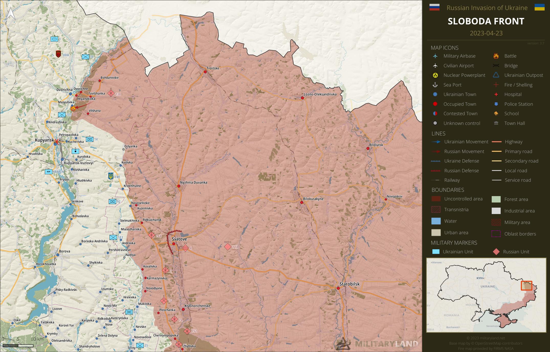
Ukrainian General Staff reports repelled attacks in the vicinity of:
- Lyman Pershyi
Siverskyi Donets
overview map of Slovyansk, Kramatorsk, Bakhmut and Lysychansk vicinity
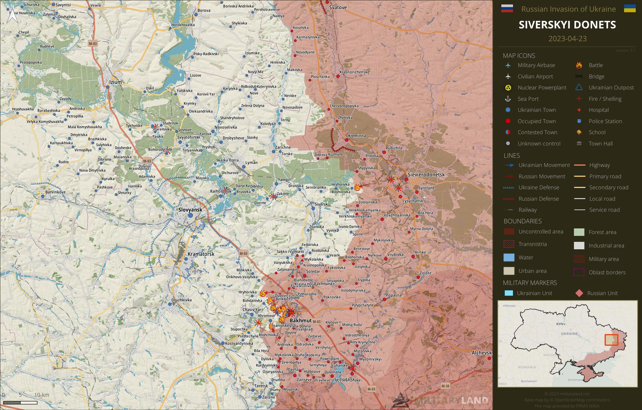
Ukrainian General Staff reports repelled attacks in the vicinity of:
- Bilohorivka
Bakhmut Front
includes the vicinity of Bakhmut
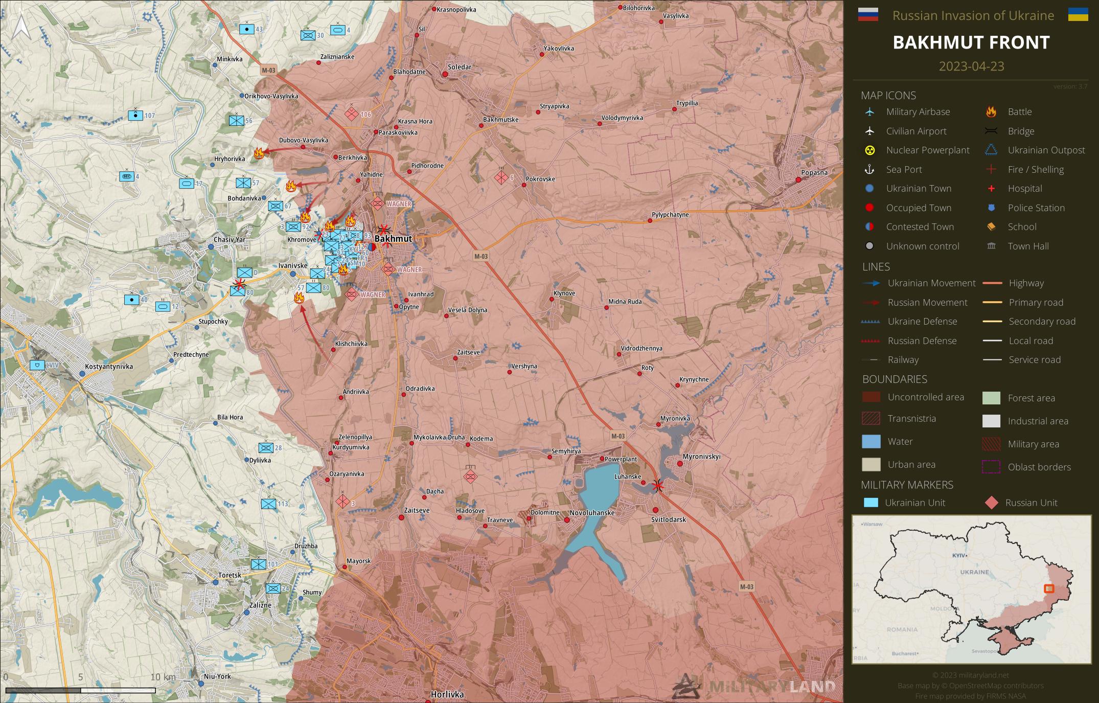
- Artillery of Ukrainian 30th Mechanized Brigade shelled Russian positions north-east of Orikhovo-Vasylivka. (source)
Ukrainian General Staff reports repelled attacks in the vicinity of:
- Hryhorivka, Bohdanivka, Khromove, Bakhmut, Ivanivske
Bakhmut City
the city of Bakhmut
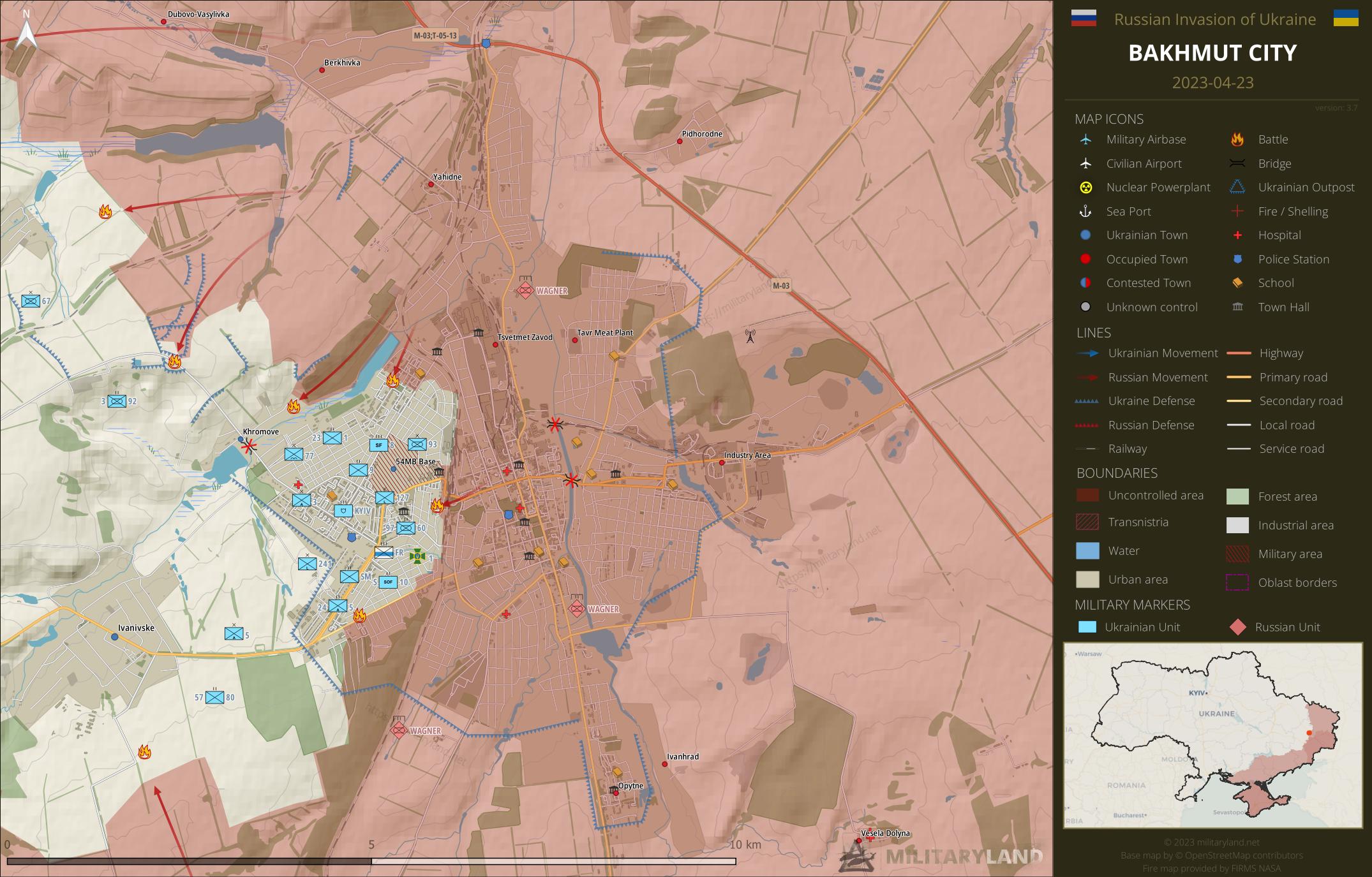
- Wagner mercenaries reached the road north-west of Khromove. Heavy fighting continues, Ukrainian defenders are attempting to push the enemy back. (source)
- The provisional bridge laid out by Ukrainian Army at Khromove was destroyed, the road is no longer usable. (source)
- Fighting continues in the area of the main train station and in the north-western part of Bakhmut.
- A tank of Ukrainian 93rd Mechanized Brigade engaged Wagner mercenaries in the south-western part of Bakhmut. (source)
Avdiivka Front
includes the vicinity of Avdiivka
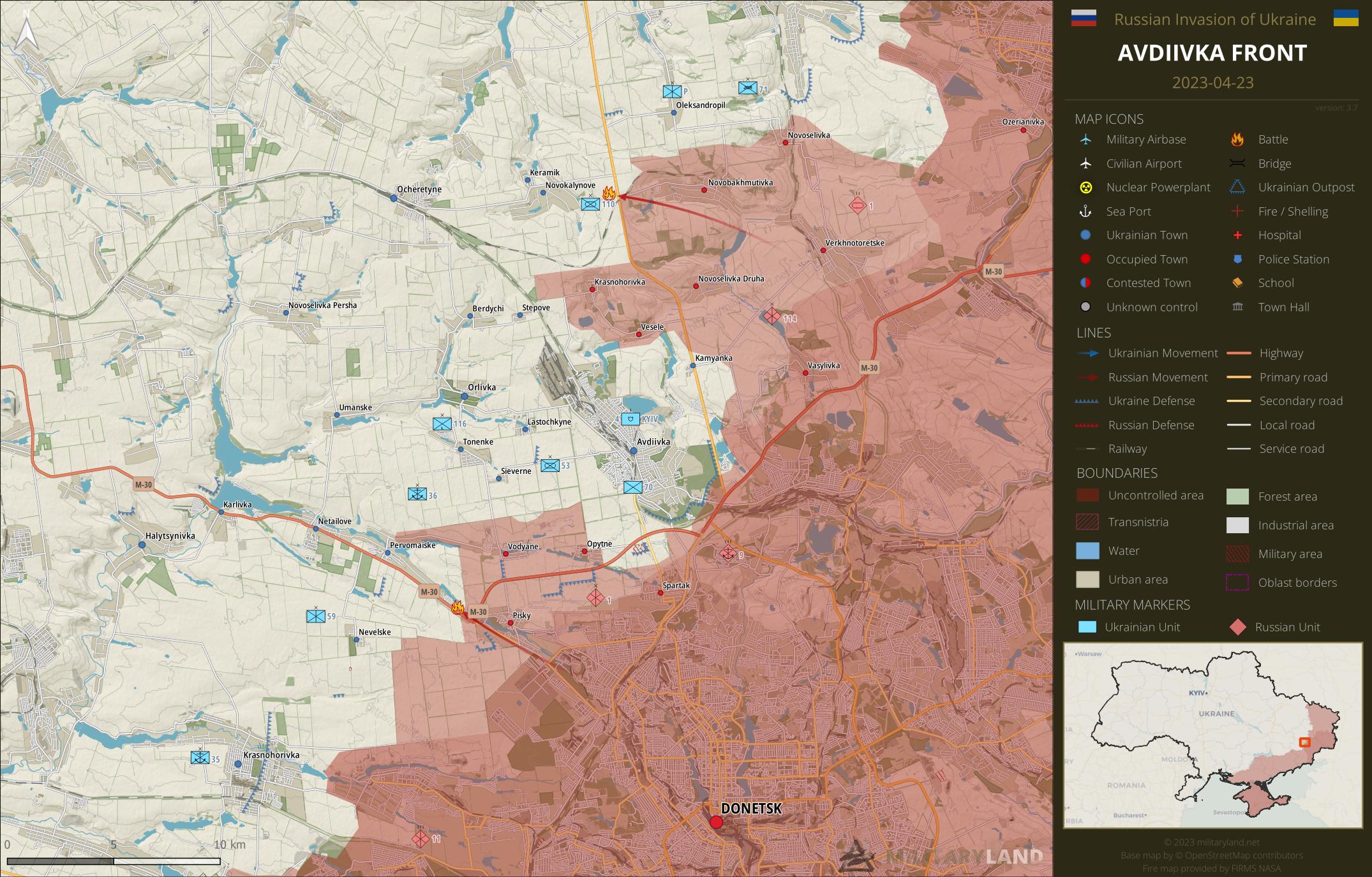
Ukrainian General Staff reports repelled attacks in the vicinity of:
- Novokalynove, Pervomaiske
Donetsk Front
includes the center and southern part of Donetsk Oblast
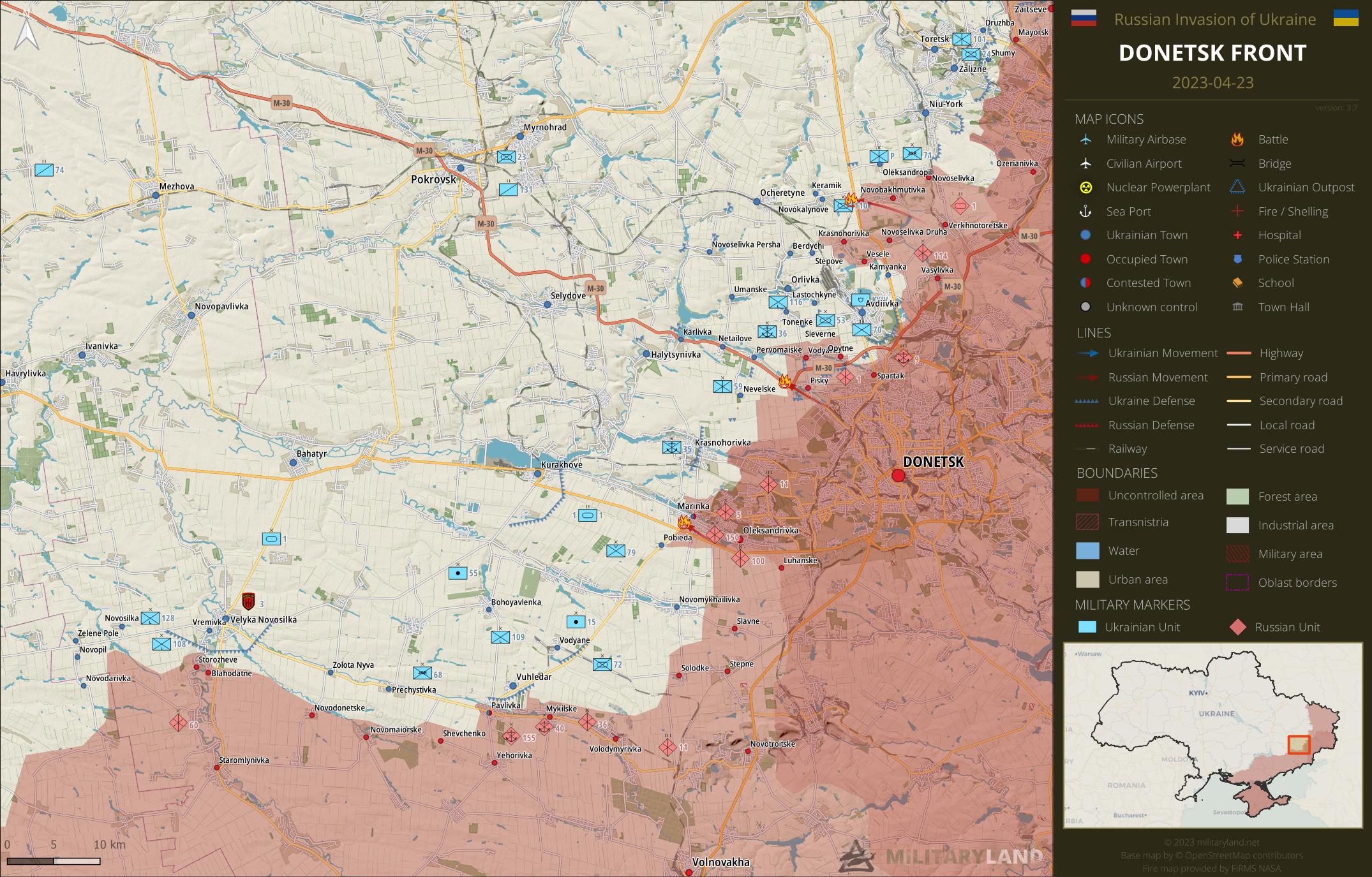
Ukrainian General Staff reports repelled attacks in the vicinity of:
- Marinka
Zaporizhzhia Front
includes the Zaporizhzhia Oblast
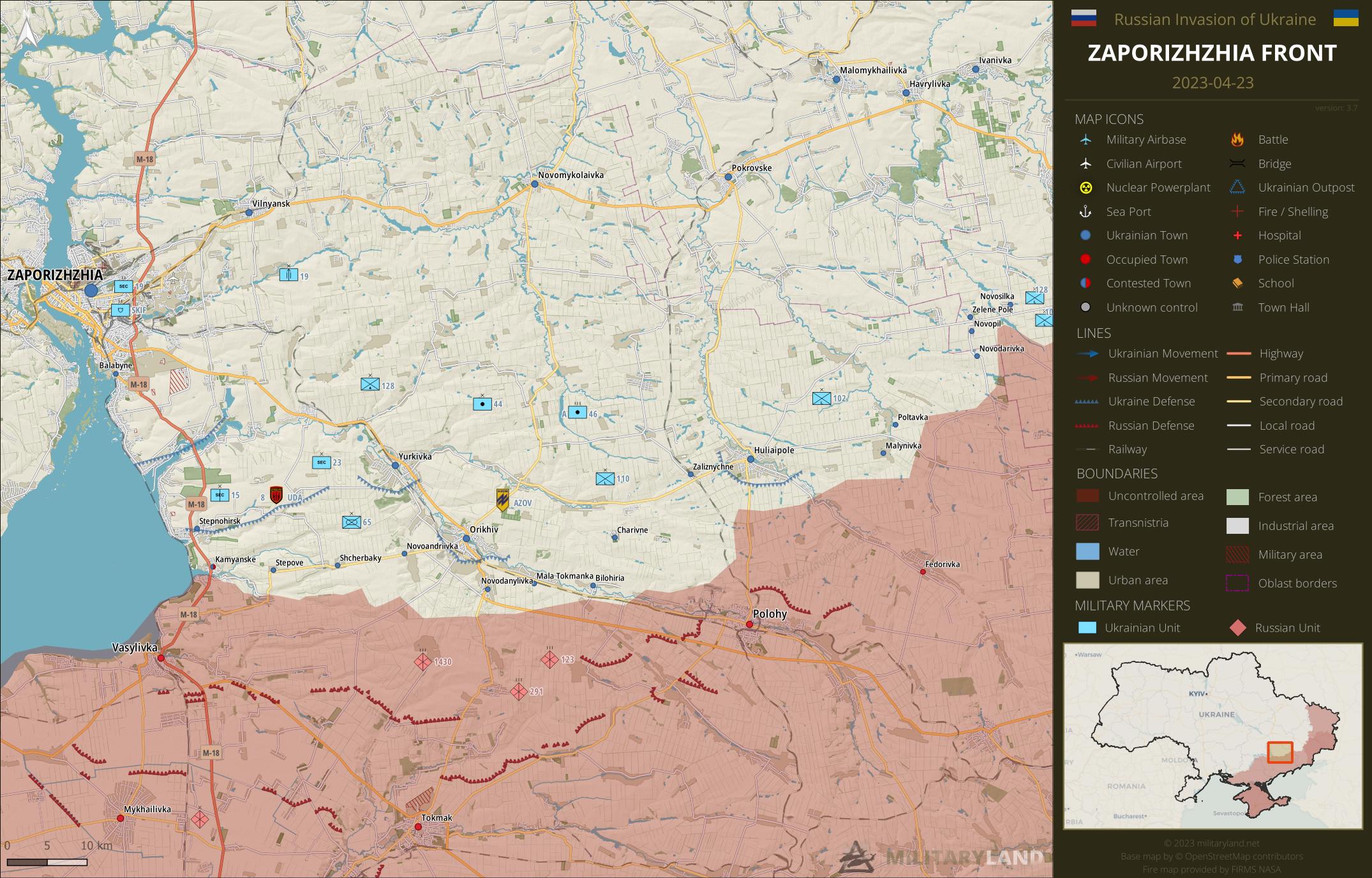
Ukrainian General Staff reports repelled attacks in the vicinity of:
- No activity reported.
Kalanchak Front
includes the left bank of Dnipro river south of Kherson and Kakhovka
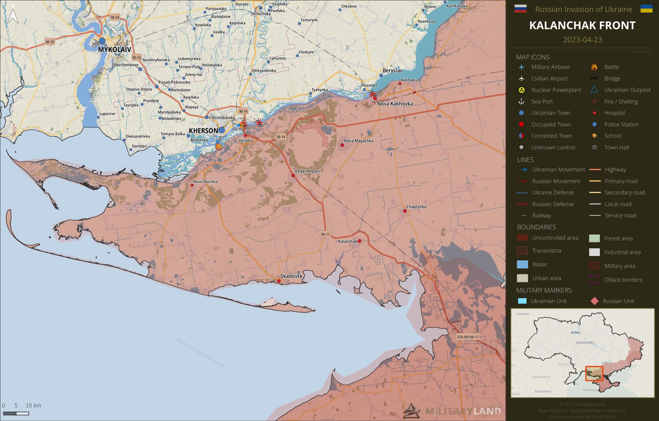
- Ukrainian reconnaissance group landed at the island north of Oleshky, and entered the dachas area. (source)
- Another Ukrainian reconnaissance group landed at Kruhlyk island and entrenched itself in the dachas area. (source)
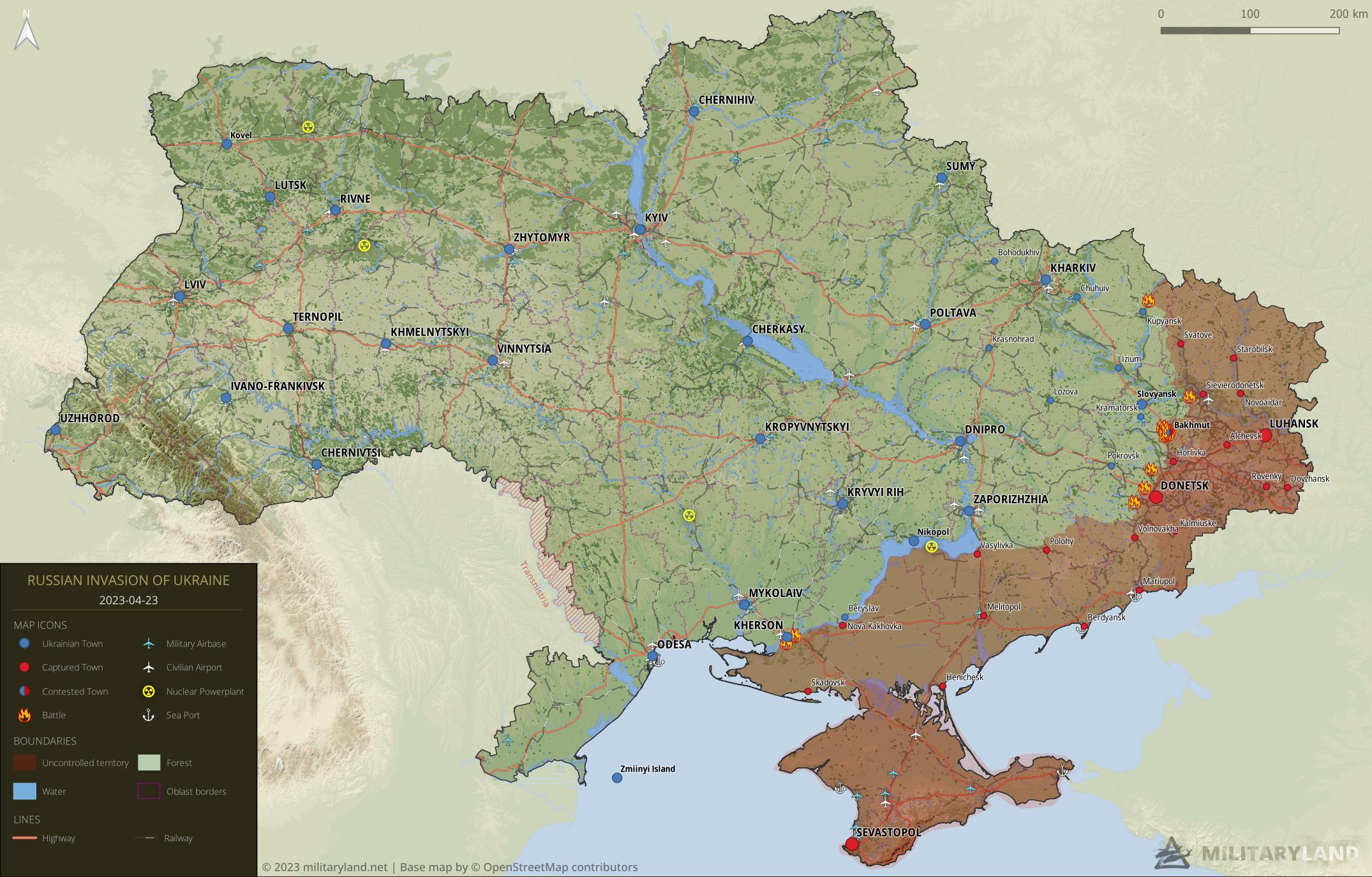
Full map
The full overview map of current situation.
Looking for an interactive map? We got you covered. Visit our original Deployment map.
If you would like to use our maps in your project, video or any other media, please visit Invasion maps page for more information.
This summary and detailed maps are based on the following sources:
General Staff of the Armed Forces of Ukraine, official media channels of Ukrainian regional administrations, Ukrainian Ministry of Internal Affairs, Security Service of Ukraine (SBU) and geolocated footage.
We also thank the following Twitter users for their geolocations and amazing work: @neonhandrail, @auditor_ya and the team at @geoconfirmed.
If you enjoy this content, the best way to support our site is by sharing it and following us on X, Bluesky and Facebook.
Topics:
Related posts
Our community
Mentioned Units
No unit mentioned.Support us
The Russians published this video near the Antonov bridge https://t.me/RVvoenkor/43456
What we are supposed to see?
I just see 2 russian talking . May be near antonov bridge. if its antonov bridge on the left bank, russia control this area since a year.
https://www.google.com/maps/@46.6602906,32.7210337,3a,40y,355.17h,94.77t/data=!3m6!1e1!3m4!1sAF1QipOn7QexlU4SzJ4i7Dve7gsgZw_GYdUVp2bde-3Y!2e10!7i1920!8i1080
vsemy pesda anyways
Ukrainian Defense Intelligence Directorate head Budanov says 120,000 Russian soldiers conscripted during fall 2022 mobilization remain in Russia and not all of them in condition to fight in Ukraine: News Outlet via Pravda Ukraine.
This confirms my long-held view that a significant proportion of the 300,000 soldiers mobilized in Sept-Nov 2022 are still not taking part in hostilities.
The 120 000 conscripted are NOT part of the 300 000 mobilized. Tha’s two different things.
Conscription happens twice a year and concern all young males to give them a first military experience. They are not supposed to fight.
Mobilization is exceptional and concern only men with former millitary experience (at least officially). They are the ones who fight in Ukraine.
If so, there is translation issue as the Budanov quote mentions both the words conscription and mobilization.
You forget the fact that people use both words interchangeably, even the Ukrainian Defense intelligence directorate head as it seems.
What he was most likely referring to were the 300k mobilised tho, given the specific time of the year in 2022.
so it is safe to assume that 120k of the 300k mobilised troops are still in Russia, training and waiting, since approx.6 months now.
“Soviet soldiers in Afghanistan lacked the proper military tactics for guerrilla warfare in Afghanistan’s rugged mountainous terrain and many of the Soviet troops were young conscripts untested in combat.” Copy from Wiki. As you see conscripts also fight. When there is mobilisation the regular conscription is cancelled as they are incorporated in the mobilisation. You sent the experienced and keep
Keep back the inexperienced. Evey draft has an average of 130-135.000 conscripts which is the number approximately of the people that are kept back for training as mentioned by Budanov.
The regular consctiption was not cancelled because of mobilization. There was a round in autumn, and another one now. The 120k are those regular conscripts who are not supposed to fight in the “special military operation” (it’s still not a war, according to Putin, so no conscript sent to fight). And so far, there are no evidence that those conscripts have fought in Ukraine.
Now, if you think that those conscripts can change anything on the battlefield, or if you think that Russia still have a massive offensive potential after the humiliating failure of their winter offensive, you’re just delusional.
The only thing that worries me is that Western countries don’t provide enough weapons and ammunition to Ukraine. That’s a shame.
He specified the period of mobilisation. It’s not conscripted soldiers. Some people just try to fabricate arguments so they can justify their claims. Possibly Russia isn’t able to support without problem 300.000 soldiers at the front at the same time so they preferred to sent a part of them an keep the rest in reserve and training. Like Ukraine also does. They don’t send whatever they have
Ruzzia also has to keep a “home” army incase NATO really do get invoved.
Also to suppress any possible uprisings.
Either Kherson is fake, or this is the very very very early reconnaissance to try get a mobile bridge so they can cross and establish a “beach head” on the other side of the Dniepr later.
Would make sense to push to Crimea to repell the russian navy and destroy the bridge linking to russia to secure the south once & for all.
But what would happen on the east front then.
Something known as a diversion ….. Like the Kharkiv / Kherson offensives … they can begin a spearhead in Crimea to pierce this front and attract Russian troops from Donbass then counter attack to Bakhmout area which will be free of Russians since Prigojine seems completely afraid of UKR counter offensive(s) see his last déclarations….
I will add that UKR army received lots and lots of pontoons and mobile bridges from France, Germany and USA… I saw ( i’m french ) lots of specialized bridges for deep rivers crossing that were transported to Ukraine
If Ukraine tries to cross the swamp in large numbers, Russia can simply blow up the Kakhovka dam and drown them. So first, they’d have to seize the dam. It’s not impossible, just very risky.
If we see something happening around the dam, then we’ll know it’s for real.
No, it’s not in the Russian strategic interest to blow up the dam. Most Russian fortifications go from west to east to block a push from the north to the south. If the dam were to be blown up, some Ukrainians would drown, but this would make any future push across the Dnipr for the Ukrainians a lot easier, since the river and the reservoir would become narrow, enabling them to bypass the trenches
You may be right. But in a scenario where the Ukrainians are already crossing the swamp, the Russians might decide that this is the least-bad option.
No it’s not, crossing the Dnipr is hard [citation needed]. If Ukrainians get stuck on the other side, all the Russians need to do is to reinforce their troops and capture the Ukrainians, since they can’t retreat. Any serious Dnipr crossings must involve a lot of soldiers and equipment
The dam to crimea canal ?
Losing the water supply to Crimea is a price that the military might be willing to pay. They’d probably think “let the civilians deal with it, it’s not our problem”.
And if Ukraine takes the left bank, they’d cut off the water anyway.
People keep talking about blowing up the Dam keep forgetting that if they do that the ZZP will melt down. They are already having water issue due to the draining of the reservoir.
Plus like that RED.misfit properly referred to the landings as a beachhead and not bridgehead so many other people are mislabeling it as. Remember Ukraine now has many APC capable of river crossings.
Crossing rivers unnoticed is very difficult. The area (within a radius of 30-40 km) would have to be liberated from the Russians beforehand. River crossing takes a long time and usually complete units are pulled together. This also makes you an easy target for attack, where an entire battalion can be destroyed with one attack.
Why would they need to build a bridge or beachhead? Why can’t Ukraine just make an offensive push from Dnipro?