Invasion Day 418 – Summary
The summary of the situation of Russian re-invasion to Ukraine covering the last 48 hours, as of 17th April 2023 – 22:00 (Kyiv time).
Sloboda Front
includes the area of between Oskil and Aydar river
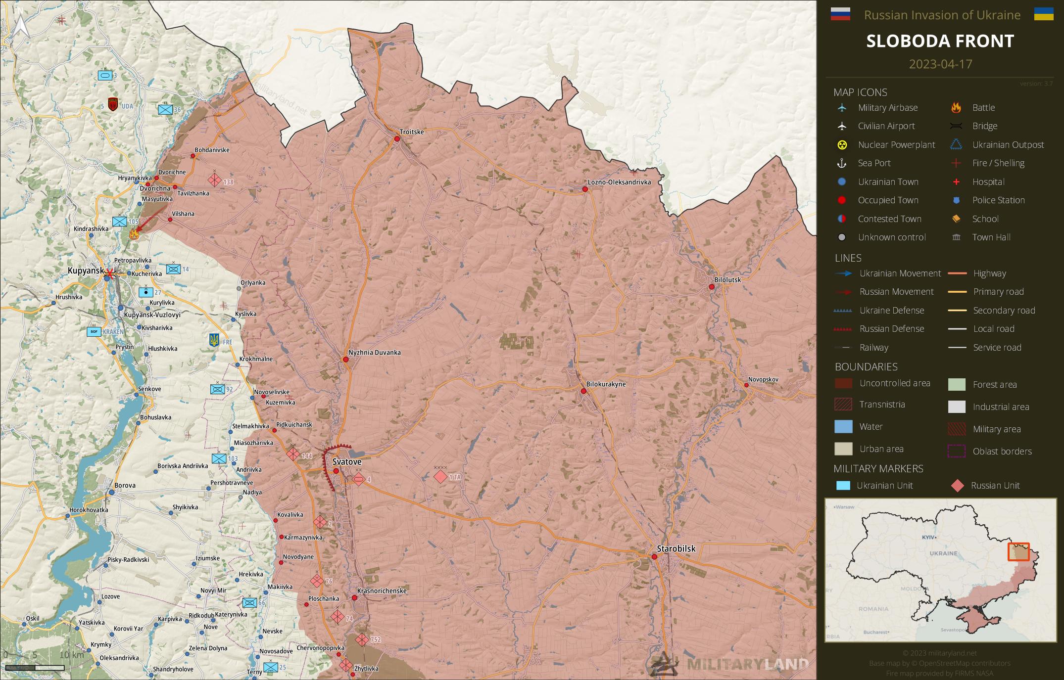
Ukrainian General Staff reports repelled attacks in the vicinity of:
- Synkivka
Siverskyi Donets
overview map of Slovyansk, Kramatorsk, Bakhmut and Lysychansk vicinity
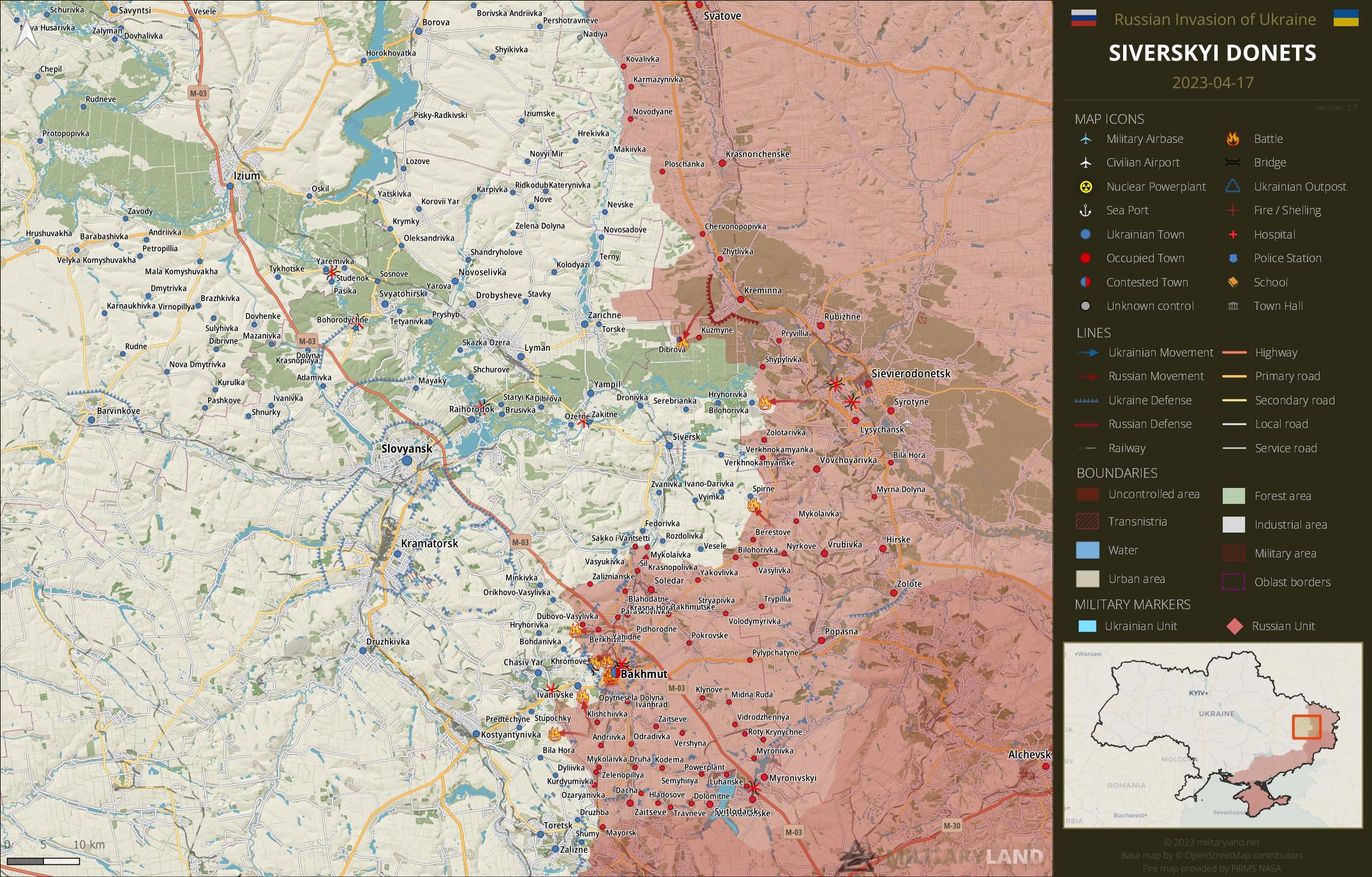
Ukrainian General Staff reports repelled attacks in the vicinity of:
- Dibrova, Bilohorivka, Spirne
Bakhmut Front
includes the vicinity of Bakhmut
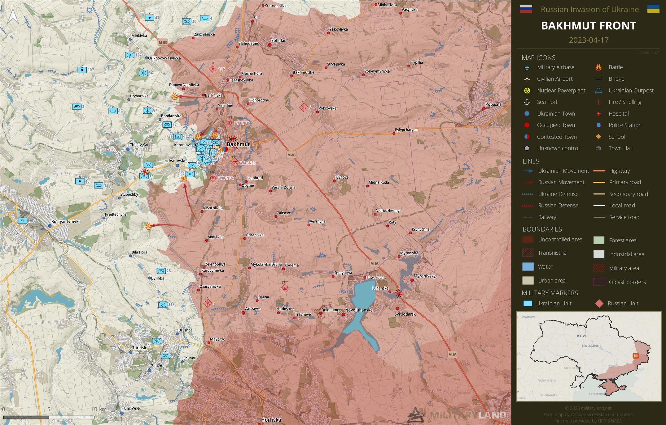
Ukrainian General Staff reports repelled attacks in the vicinity of:
- Hryhorivka, Khromove, Bakhmut, Ivanivske, Predtechyne
Bakhmut City
the city of Bakhmut
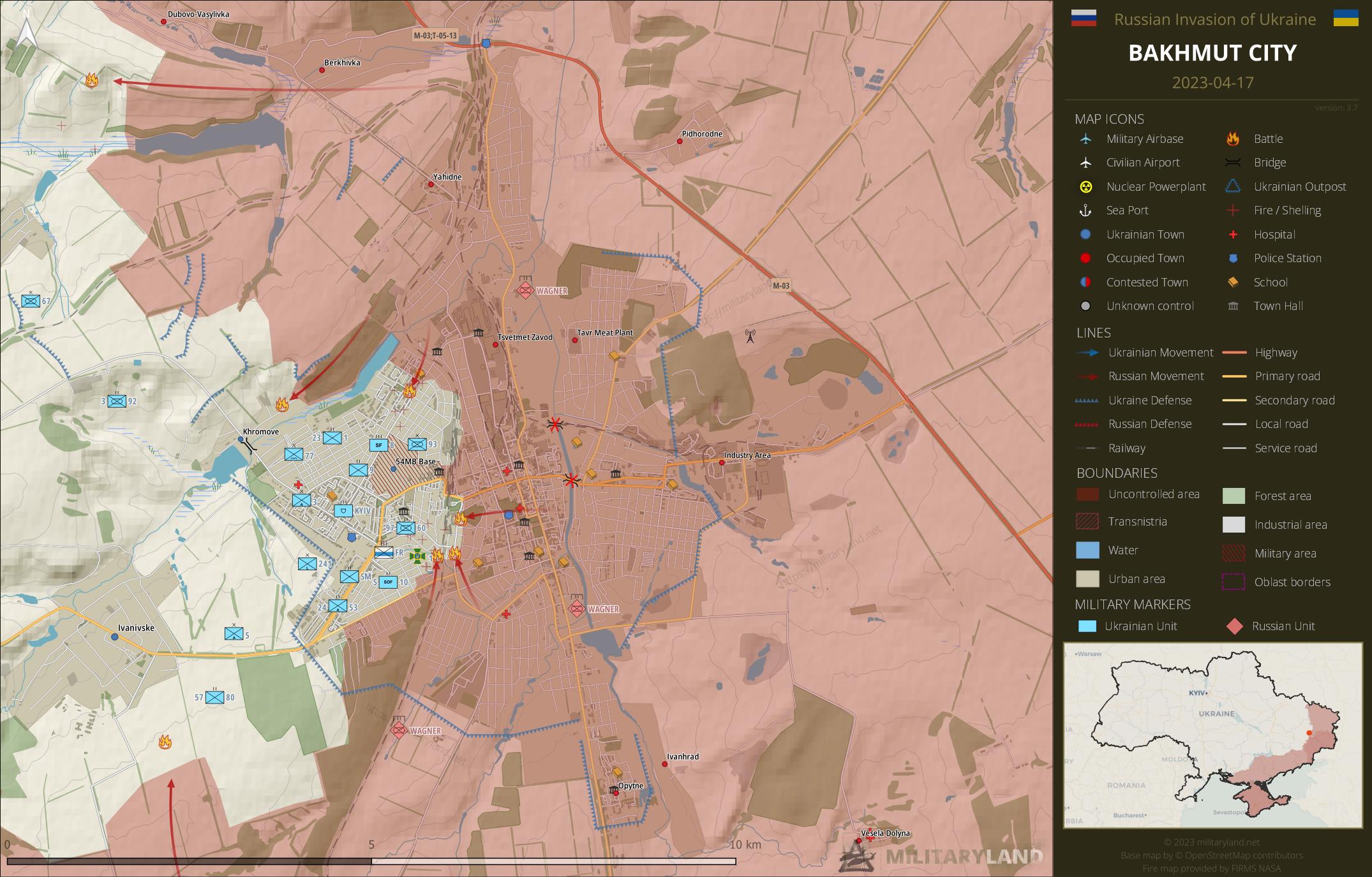
- Wagner mercenaries advanced by a few buildings in the north-western part of the city. (source)
- People’s House in the north-western part was blown up. (source)
- The enemy advanced north along the railway in the southern part of Bakhmut. (source)
- Given the Russian advance near the railway, it is likely that the area east of it shrank as well.
- Ukrainian troops remain in control of the main route from Bakhmut towards Ivanivske. (source)
Avdiivka Front
includes the vicinity of Avdiivka
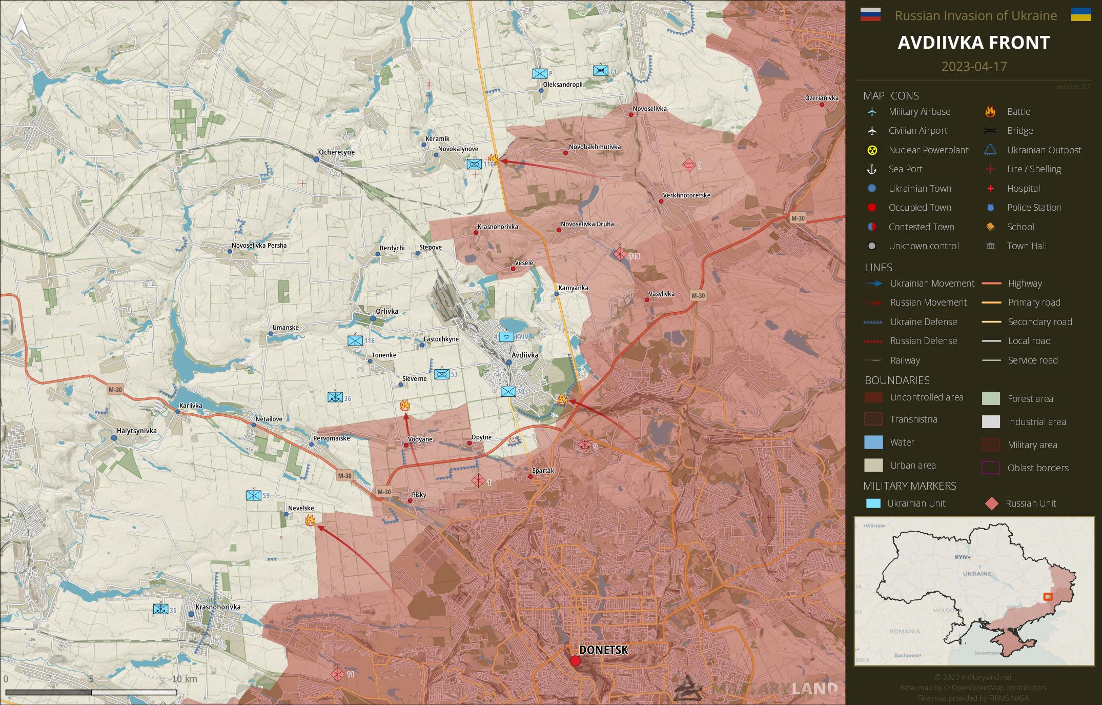
- Tankers of 36th Marine Brigade were relocated to the vicinity of Novokalynove to support 110th Mechanized Brigade. They targeted Russian troops east of the town, confirming marking from the previous summary. (source)
- Russian forces hit a Ukrainian positions near Nevelske with TOS-1A MLRS. (source)
Ukrainian General Staff reports repelled attacks in the vicinity of:
- Novokalynove, Avdiivka, Sieverne, Nevelske
Donetsk Front
includes the center and southern part of Donetsk Oblast
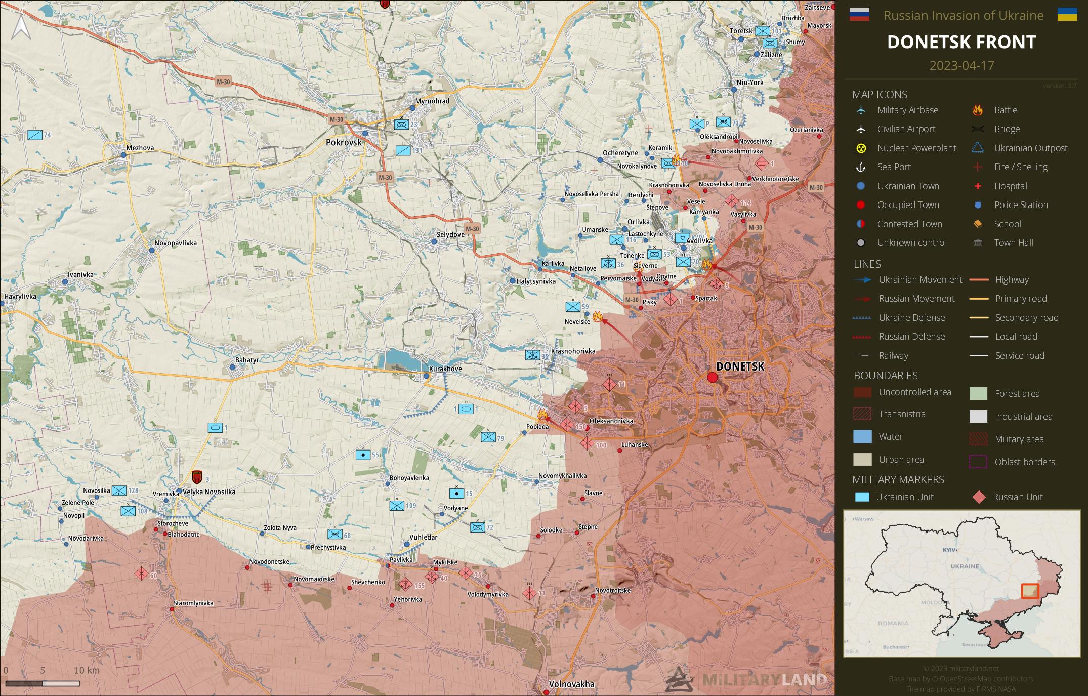
Ukrainian General Staff reports repelled attacks in the vicinity of:
- Marinka
Zaporizhzhia Front
includes the Zaporizhzhia Oblast
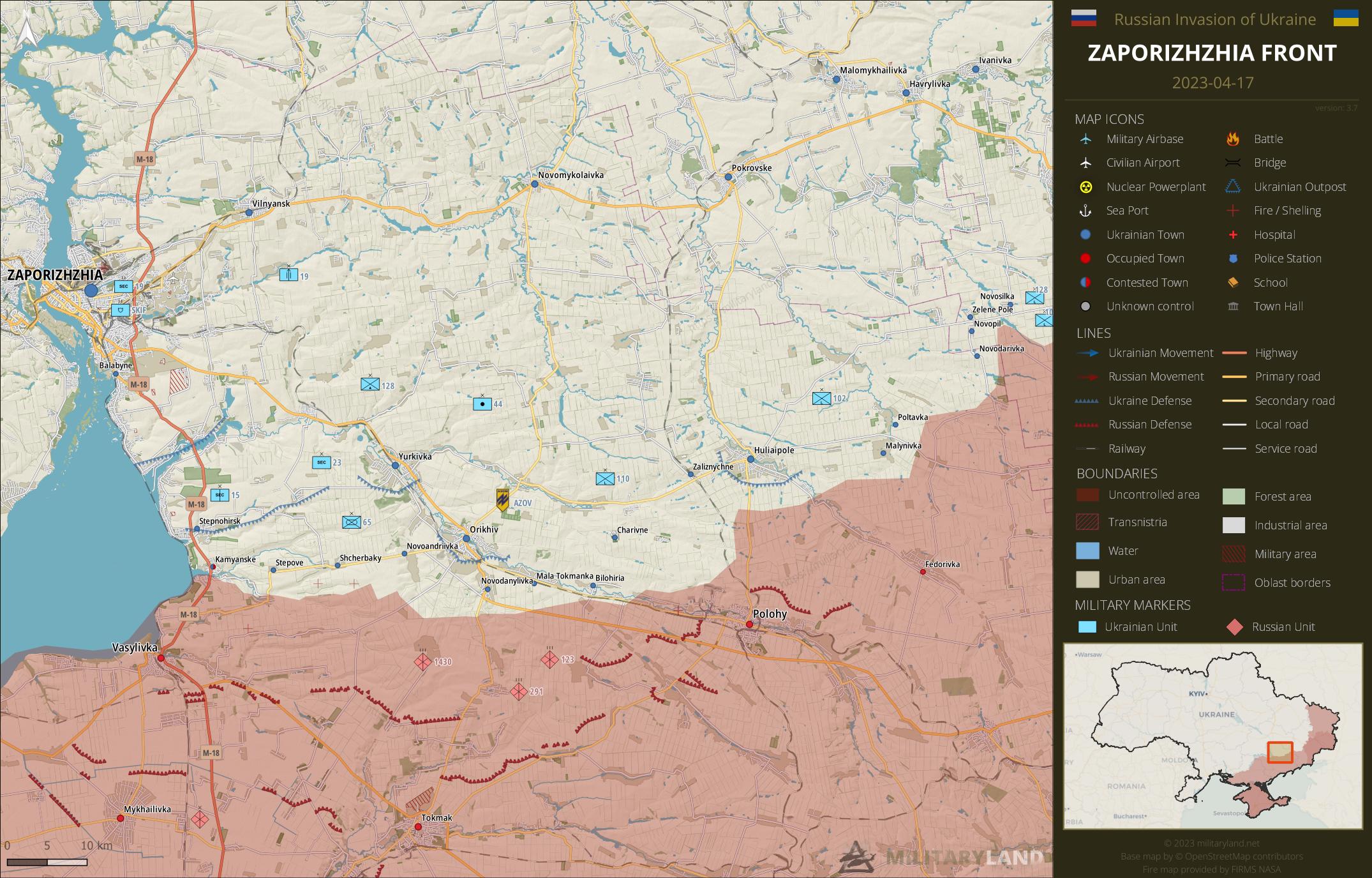
Ukrainian General Staff reports repelled attacks in the vicinity of:
- No activity reported.
Kalanchak Front
includes the left bank of Dnipro river south of Kherson and Kakhovka
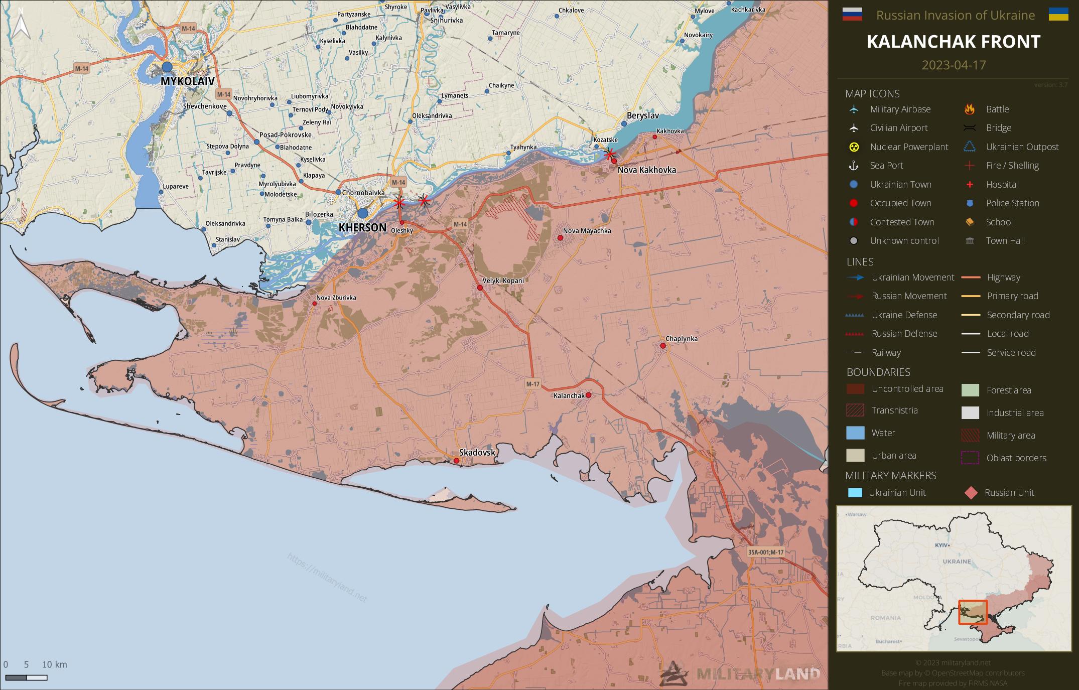
- No change on the ground during the past 48 hours.
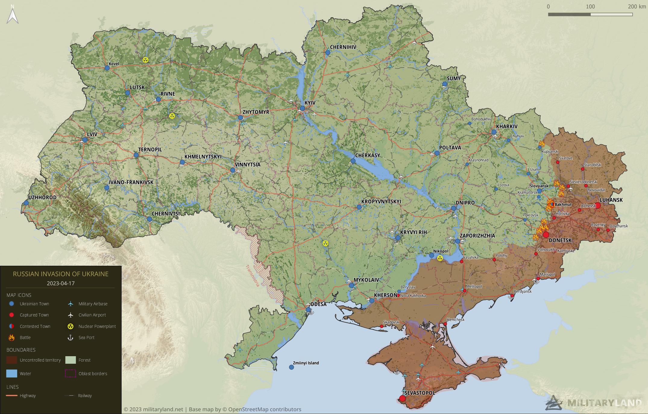
Full map
The full overview map of current situation.
Looking for an interactive map? We got you covered. Visit our original Deployment map.
If you would like to use our maps in your project, video or any other media, please visit Invasion maps page for more information.
This summary and detailed maps are based on the following sources:
General Staff of the Armed Forces of Ukraine, official media channels of Ukrainian regional administrations, Ukrainian Ministry of Internal Affairs, Security Service of Ukraine (SBU) and geolocated footage.
We also thank the following Twitter users for their geolocations and amazing work: @neonhandrail, @auditor_ya and the team at @geoconfirmed.
If you enjoy this content, the best way to support our site is by sharing it and following us on X, Bluesky and Facebook.
Topics:
Related posts
Our community
Mentioned Units
No unit mentioned.Support us
What happened to Rifle brigade of air forces of Ukraine. Where is it located? I can’t find it in the least.
Look on the Deployment Map north of Kyiv.
Not true. I misread your commend. Sorry. The Reserve Rifle Brigade is marked to be north of Kyiv. If the Air Force Rifle Brigade is not on the map, then the whereabouts are not public.
A bit off topic but what happened to the 3rd and 8th Special Purpose Regiments? I thought they were part of the Special Operations Forces, but I cannot find them there or anywhere else in the Ukraine OOB.
Hello, they are called the Special Operations Center East (3rd) and the Special Operations Center West (8th). Don’t know why. At least the Wikipedia page of the 3rd shows the new name, the page of 8th Regiment does not.
The 3rd and 8th Special Purpose Regiments have new names. Special Operations Center East and West.
Much thanks. Was also wondering about the 73rd Special Maritime, but based on your answer, I assume they became Special Operations Center South. It all makes sense now!
Yes, they officially renamed all the SSO units some time ago, but the general public and even official social media continue to refer to them by numbers.
An interesting interview of an Ukrainian artillery commander: mostly about Ukrainian counteroffensives (past and future ones), but he also talk about bakhmut and why it is important to defend it from a strategic point of view.
I think Bachmuth will fall into the hands of the Russians at the end of
April. At some point, the drop will have been made and there will simply
be nothing left to defend. And now that TOS are constantly being
deployed, it’s just not worth it for the Ukrainians to lose lives. And
before they fall into the hands of the Wagners as prisoners, I would
rather draw a line.
Sorry, Google Translate did a bad job of translating my text above.
I just wanted to say that there comes a time when holding on isn’t worth holding on to. The Ukrainians have to admit that the Russians would fight for Bachmuth for two more years as long as the Ukrainians are there.
Well, that is the reason why they defend it, so russia keeps attacking, impaling itself.
The Russians are speculating that the Ukrainians will eventually give up the city. Both sides are stubborn as oxen and this is really about who has the staying power. But as long as the Russians have human flesh, you can’t get them out of there. And then there is the question of whether it is still worth defending against an opponent who is stuck.
Russian dont have lot of human flesh right now.
Wagner troops are depleted and russian army IS now thé principal force in bakmut.
But they have to stop other offensives to find the meat to send to the grinder.
Russians running out of man? No. We don’t even know if they have send in the full 300k men to the front yet
Wagner depleted? No, but their contract should run out soon I believe
Russian army being the main contributor in bakhmut? No, it’s still the Wagnerians, but Russian Special units do help out quite a lot
There weren’t any other offensives planned, they are waiting for Ukraines first
I agree. Concerning Wagner, they lost a lot of men for sure but they are also recruiting in dozens of centres across Russia.
last year wagner was fighting on 80 km of frontline. after that, only bakmut area. after that, only bakmut. 2 weeks ago, only 3 km in central bakmut. And now, wagner are in minority everywhere in bakmut. mobiks and regular army making the principals attacks during past days.
But yes, everythings happen like in the plan.
This is about demography. Russians have more soldiers, more reserves, and much more people, in general. So, we don’t know how many ukranian soldiers died. It’s state secret… to lift the morale. But let’s say we really believe the russians are dying like flies, and, for whatever reason, the ukranian soldiers only get slightly injured or leg cramps, or something. Even so, Russian have an advantage
at the start of the war wagner was waay smaller than they are now like maybe 10k. now they are at about 50k that they have a smaller front has NOTHING to do with their manpower. also the russia army is not the main contributor in bakhmut. they do help out but they are maybe 5-10% off all forces and i’m very generous in that assumption videos suggest way less tho where did you got… Read more »
Wagner at the start of war: ~10-20k. They recruited at least 40k inmates, so they were about 50k in november/december. Most of them died/ were injured and they are something like 5k-10k now.
What dolgan said is true: Wagner is not the main force in Bakhmut anymore. It’s the VDV and other regular Russian units.
From where comes this sudden new information?
osint source, videos, prisoners, prigojine himself, etc
its not sudden. Wagner power decrease slowly along past months.
Ukrainian officials have claimed that nearly 30,000 of Wagner’s fighters have deserted or been killed or wounded, a figure that could not be independently verified.
https://www.reuters.com/world/europe/prigozhin-ammunition-output-is-up-still-worry-wagner-russian-army-2023-03-10/
We will learn something approximating the real figures from both sides after the war, when the dust settles
If Wagner is really down to 5-10K (which I doubt) in 1 or 2 months they should be gone as a fighting force. We won’t have to wait much to find out.
One could also claim Ukraine is dangerously burning its strategic reserves
1/2 The argument is persistent, but i think it is a russian narrative. If you “burn your strategic reserves” while doing a fighting retreat in a city, than you are loosing the war, since it is basicly the most effective thing to do. So a good reason to plant that idea in russian propaganda. On the other hand, if you fear that your opponent will stop attacking, as soon as he has conquered the
2/2 City. It may make a lot of sense, to defend it more stubbornly to degrade him befor your own attack.
This is very much on point