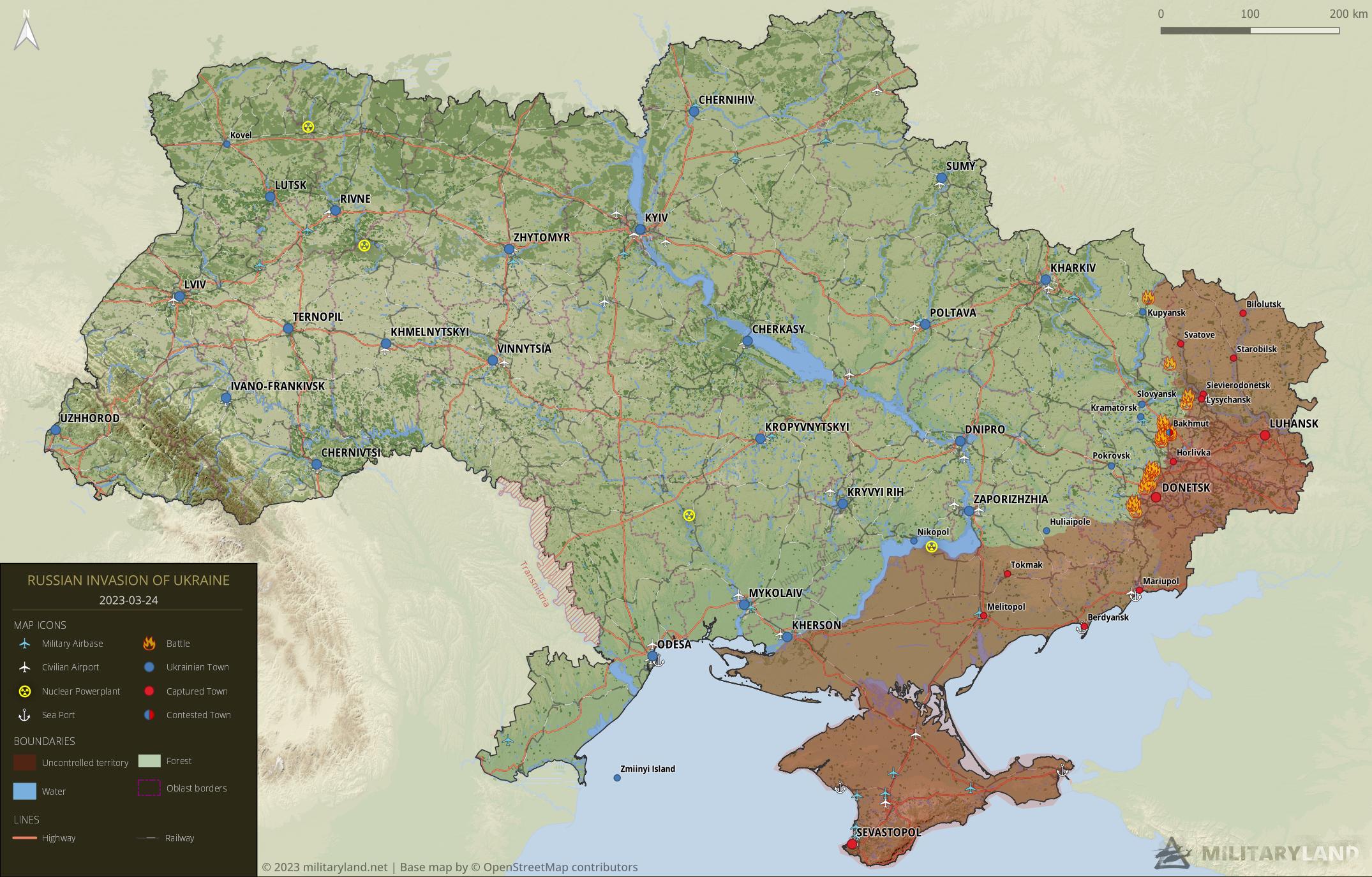
Invasion Day 394 – Summary
The summary of the situation of Russian re-invasion to Ukraine covering the last 48 hours, as of 24th March 2023 – 22:00 (Kyiv time).
Sloboda Front
includes the area of between Oskil and Aydar river
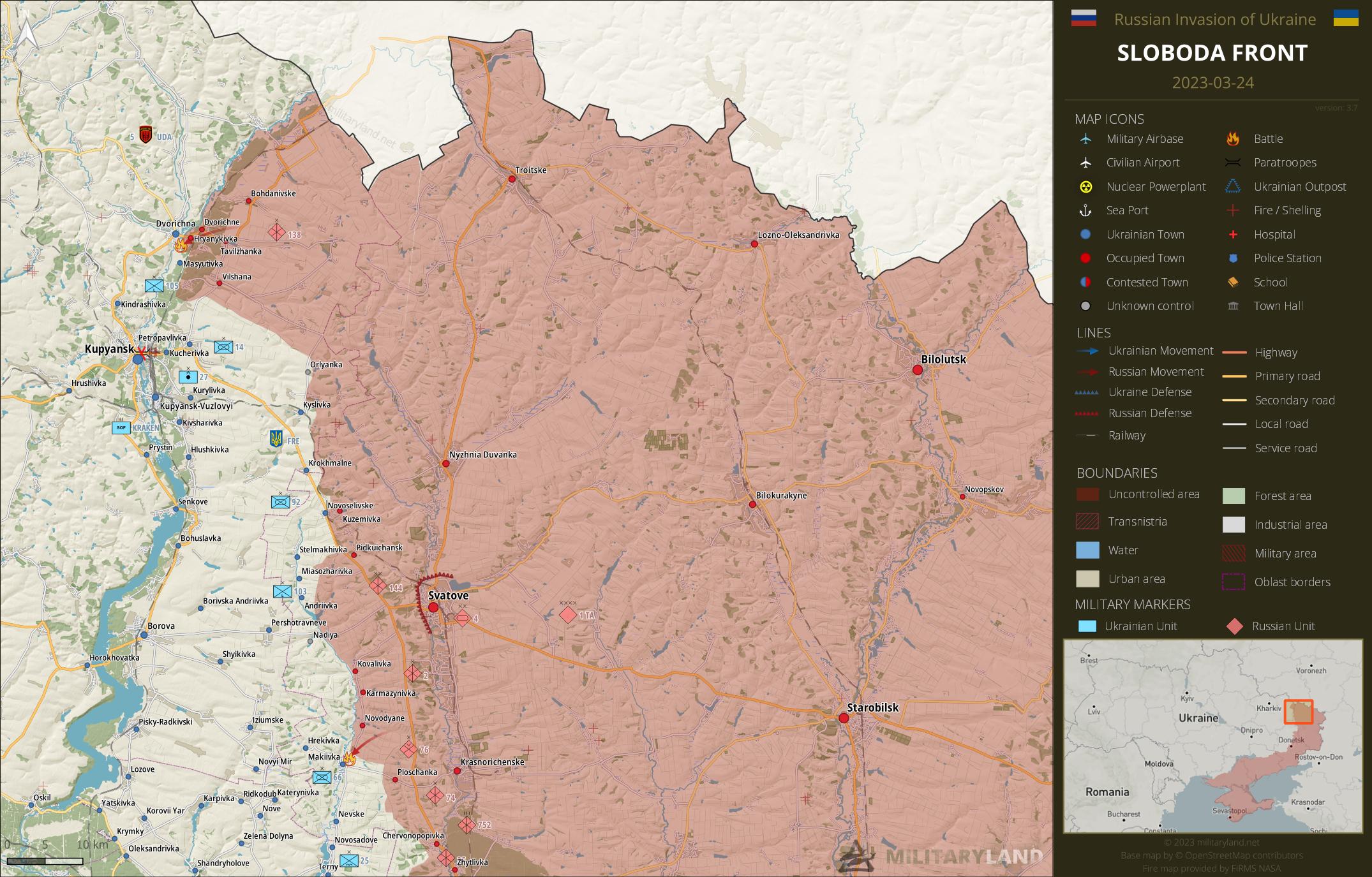
Ukrainian General Staff reports repelled attacks in the vicinity of:
- Hryanykivka, Makiivka
Siverskyi Donets
overview map of Slovyansk, Kramatorsk, Bakhmut and Lysychansk vicinity
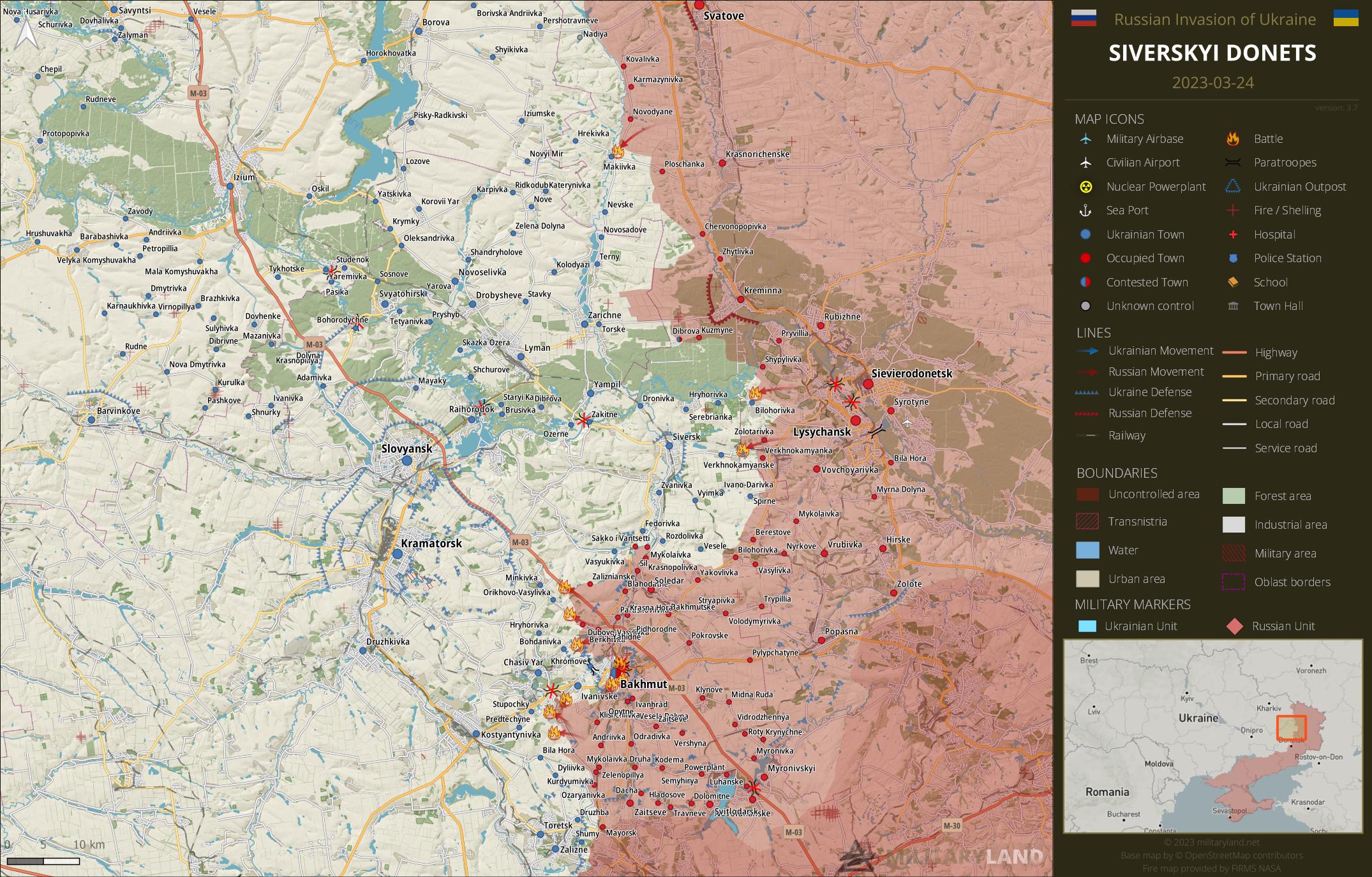
- Soldiers of 54th Mechanized Brigade repelled a Russian attack in the vicinity of Verknokamyanske. (source)
Ukrainian General Staff reports repelled attacks in the vicinity of:
- Verknokamyanske, Bilohorivka
Bakhmut Front
includes the vicinity of Bakhmut
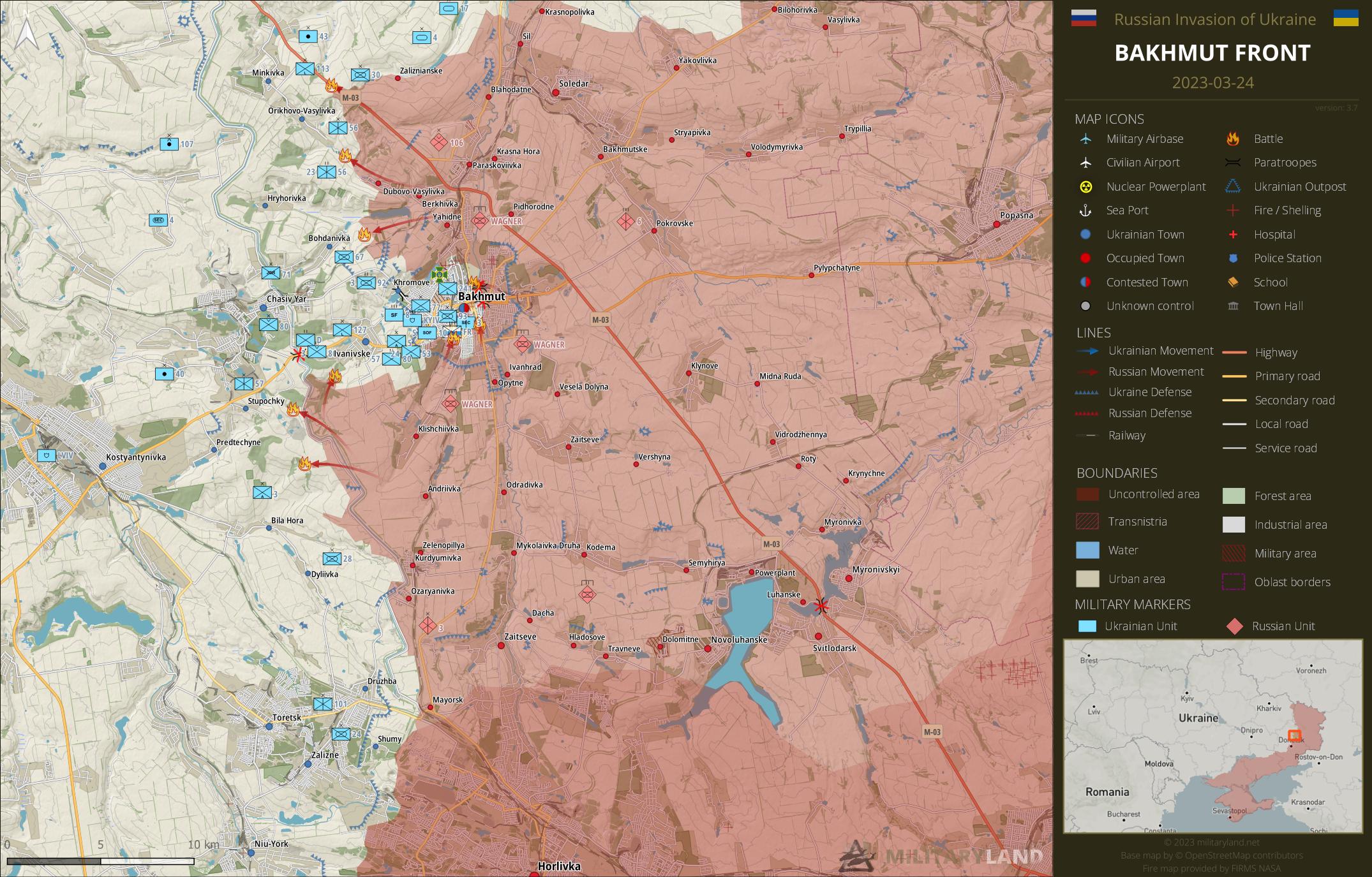
- The enemy advanced along M-03 highway towards Minkivka. (source)
- Russian troops also advanced in the area west of Zaliznianske settlement. (source)
- Wagner mercenaries managed to push closer towards Ivanivske. (source)
Ukrainian General Staff reports repelled attacks in the vicinity of:
- Orikhovo-Vasylivka, Bohdanivka, Bakhmut, Stupochky, Predtechyne
Bakhmut City
the city of Bakhmut
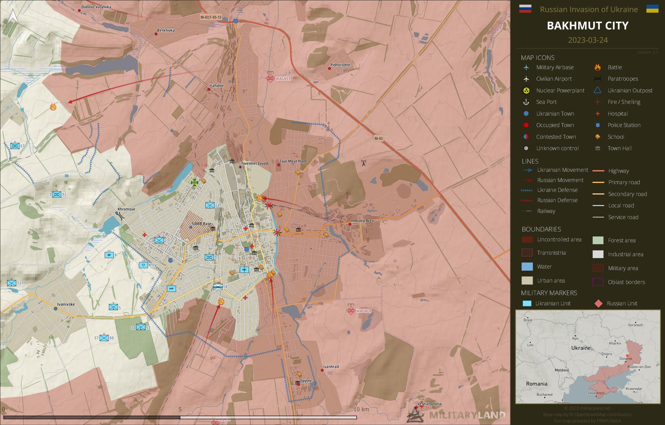
- The enemy crossed Bakhmutovka river and captured the garage area. (source)
- Wagner mercenaries advanced in the southern part of Bakhmut and reached the nearby school. The enemy is just a few meters away from the city center. (source)
Avdiivka Front
includes the vicinity of Avdiivka
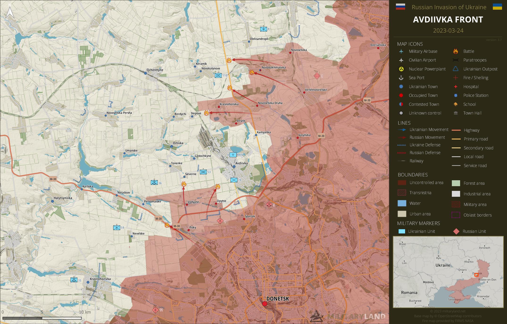
- Ukrainian General Staff reported for the first time a repelled Russian attack in the direction of Keramik, indicating a Russian advance towards the settlement.
Ukrainian General Staff reports repelled attacks in the vicinity of:
- Novobakhmutivka, Novokalynove, Keramik, Avdiivka, Stepove, Sieverne, Pervomaiske
Donetsk Front
includes the center and southern part of Donetsk Oblast
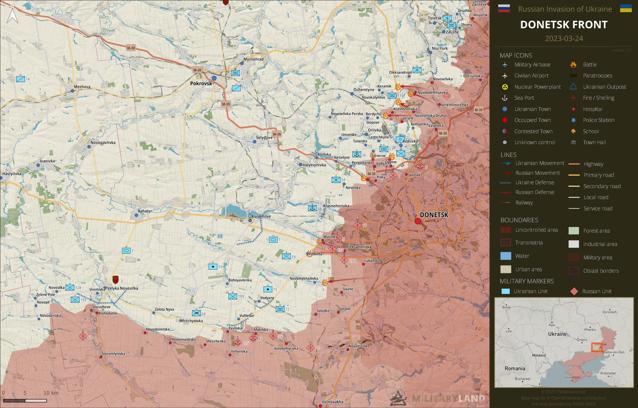
Ukrainian General Staff reports repelled attacks in the vicinity of:
- Marinka, Pobieda, Novomykhailivka
Zaporizhzhia Front
includes the Zaporizhzhia Oblast
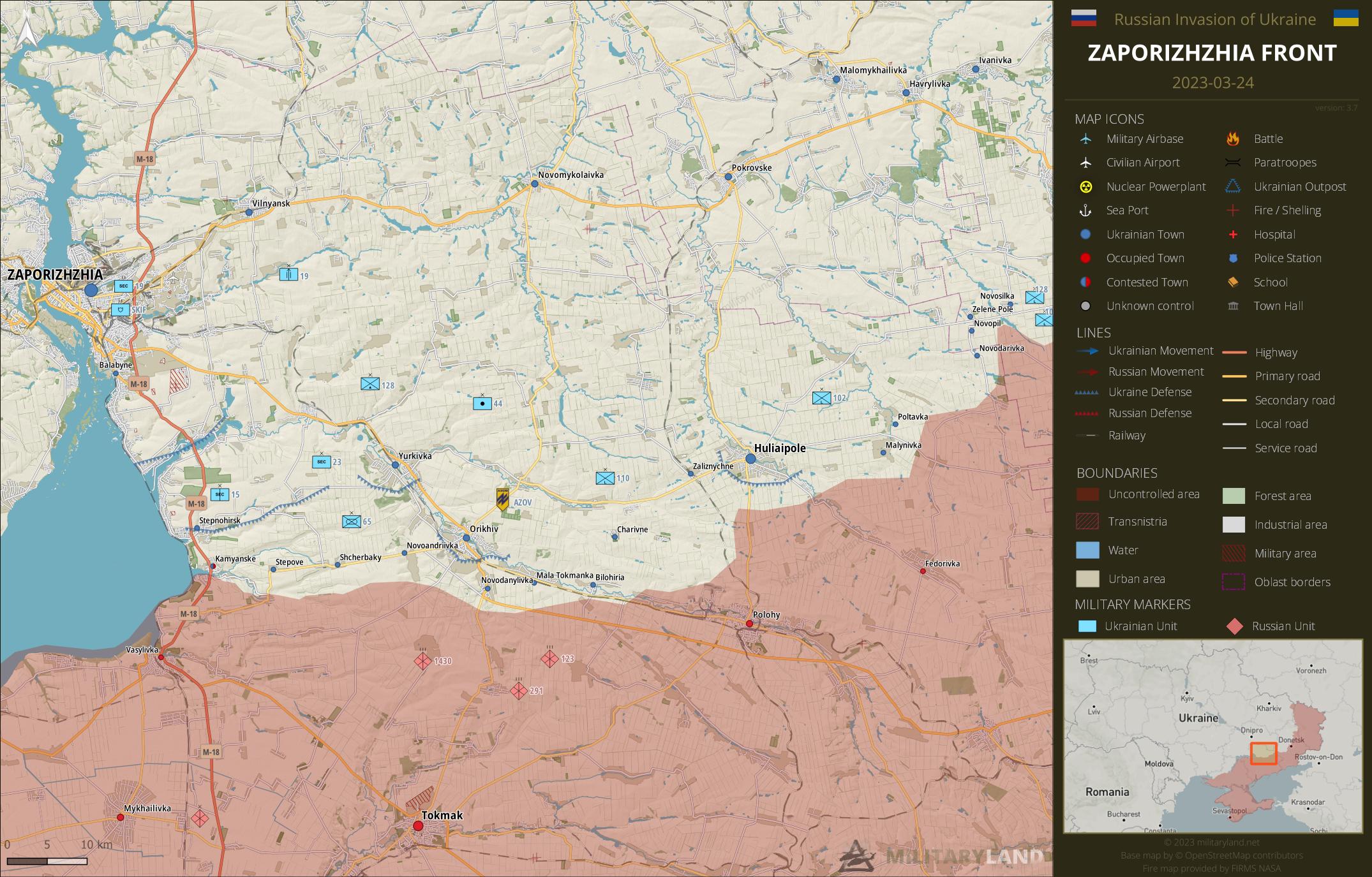
Ukrainian General Staff reports repelled attacks in the vicinity of:
- No activity reported.
Kalanchak Front
includes the left bank of Dnipro river south of Kherson and Kakhovka
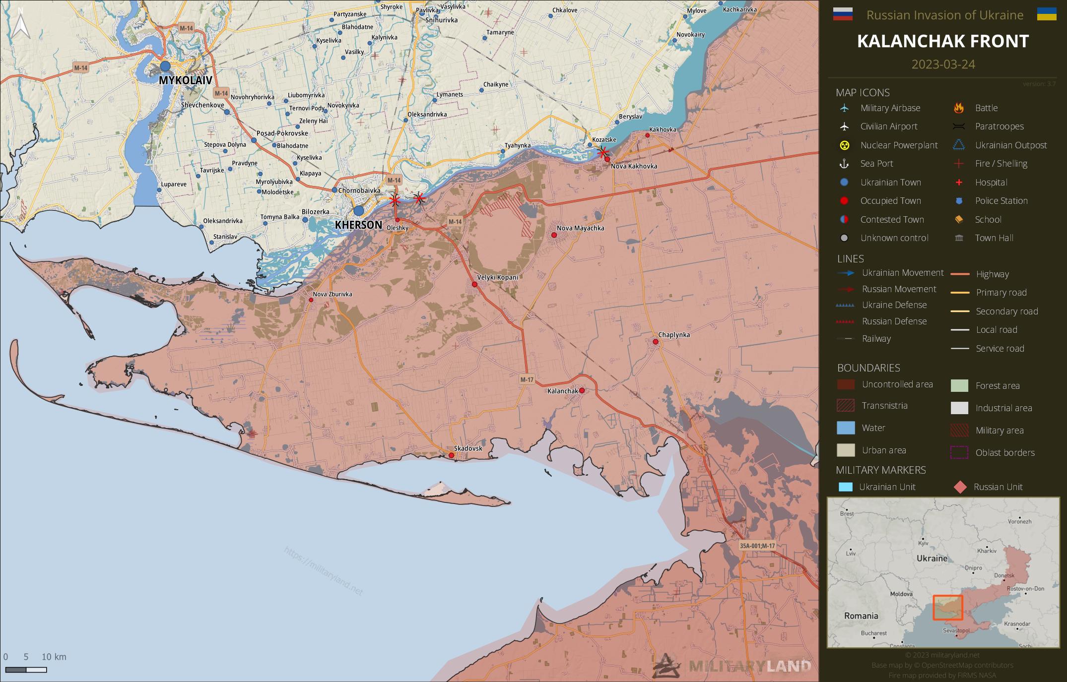
- No change on the ground during the past 48 hours.
Full map
The full overview map of current situation.
Looking for an interactive map? We got you covered. Visit our original Deployment map.
If you would like to use our maps in your project, video or any other media, please visit Invasion maps page for more information.
This summary and detailed maps are based on the following sources:
General Staff of the Armed Forces of Ukraine, official media channels of Ukrainian regional administrations, Ukrainian Ministry of Internal Affairs, Security Service of Ukraine (SBU) and geolocated footage.
We also thank the following Twitter users for their geolocations and amazing work: @neonhandrail, @auditor_ya and the team at @geoconfirmed.
If you enjoy this content, the best way to support our site is by sharing it and following us on X, Bluesky and Facebook.
Topics:
Related posts
Our community
Mentioned Units
No unit mentioned.Support us
Bakhmut will not fall
It is widely speculated that general staff of Ukraine army reported that they repelled Russian attack near novobakhmutivka 5km west of the novobakhmutivka,which is near the railway South of orchesture. it means that Russian advanced along the railway ,hope you can change the sign here
The attack in the vicinity of Verknokamyanske was recorded by drone operators of the 54th brigade. It is available here. The fight is brutal; apparently, there were about 30 Russians vs 8 entrenched Ukrainians. Ukrainian infantery men pin down the Russians while Ukrainian artillery (guided by drones) kill them.
Forgot to add this one, thanks! It’s there now.
This is a good example of how not to do it in any case. To attempt to attack enemy positions in the open field without motorized armored protection is the most stupid strategy of all.
Probably this is the reason why the Russians hardly make any progress and have so many losses. From the military-strategic point of view everything is done wrong.
Already at the first shell impacts they should have dispersed and retreated. But if all of them continue to advance like a bunch of chickens, it is clear that all of them will be destroyed with a few shells.
Here, mobilized inexperienced men are sent to certain death due to wrong decisions, which could have been avoided with a little more intelligence from the leadership.
They have the choice. Try to be capture by ukr alive. Or die for putin.
Ukrainians usually treat their prisoners of war well…. They abide by the Geneva Conventions, otherwise the West will stop their deliveries.
I would rather be captured by them, because at least you have a roof over your head and warm food, as long as you are not exchanged.
No, they don’t!
Yes, they do.
Best chance of survival for a russian soldier is a quick surrender.
Hmm… You haven’t read the latest UN report on POWs
This only proves that the UN has long been dominated by Putin.
No. That only proves Patrick is good on cherry-picking. The report actually says that while ill-treatment of POWs took place on both sides, but was it was far more common against Ukrainians.
And UN inspector were allowed to have access to Russian POW in Ukraine, but denied access of Ukrainian POW in Russia. Guess who is hidding something…
I will remind you that the UN reports states that 25 Russian POWs were killed upon surrender vs 15 Ukrainian POWs. Who’s cherry-picking?
Do you need a report? See what happens when they exchange prisoners. Who gives back more prisoners. Not in a single exchange did Ukraine gave back more Russian prisoners. Always Ukrainians are more by largely bigger margin in every exchange.
The UN report concludes : “OHCHR observed that, in
overall terms, POWs in the hands of Ukraine were treated in better fashion, once held in transit and
permanent places of internments”
You quote a number out-of-context and use it to pretend to “prove” the contrary – that’s the definition of cherry-picking.
Last thing (then I stop another of this useless discussions): if you think that there are only 15 cases of Russian summary executions, you’re dead wrong. The actual number is far greater; e.g. it doesn’t include the 53 Ukranian POWs killed in Olenivka prison, and many others. Unlike Ukraine, Russia did not cooperate with the UN inspectors, so there are plenty of hidden Russian warcrimes.
Chill out. Where did you see that i was proving anything? The argument was that the Ukrainians generally treat prisoners well and abide by IHL. They don’t and neither do the Russians.
“generally” (a keyword) yes they do – especially considering the situation (invaded, weaker side fighting sometimes as insurgency, presence of irregulars, limited resources, destruction of infrastructure etc.).
Before being treated well or badly, one needs to stay alive. Given the the 25/15 figure, I’d be statistically speaking more inclined to surrender to the Russians.
If you want use the stat of this rapport, respect their conclusion.
Not just cherry pick what you want and consider the rest invalid.
You haven’t read my previous posts and are mixing apples and pears. I am referring to available/proven UN figures of executed POWs. I don’t know what ‘conclusion’ you are referring to that would contradict these figures.
Yes i read them and the other answers.
This report says, that after being sent away from the front they are treated well enough. It doesn’t say what happens to them for example after they have made an attack and get captured because e.g got injured or shell shocked. It’s paradox to exchange smaller numbers of prisoners when definitely they capture more than the Russians. Either they kill them on the spot or not treat their injuries.
Actually, Russians captured more Ukrainians (about 7k, according to Volya media) than the opposite (about 2k). You capture many POWs when your offensive is successful (most Ukrainian POWs were captured during the first months and in Mariupol), not so many when defending.
But this is what i say. Russians attack in waves unsuccessfully. With every attack they leave behind injured people. Surely the Ukrainians should be able to capture more people than a few thousands. If they don’t it’s either because they are killed on the spot or left to die from their injuries.
The ruzzians often leave their wounded behind.
Exactly! And according to Geneva convention they should be treated as soon as possible and as best as possible. It’s a war crime if you just let them bleed to death.
If you defend an entrenched position, and after a failed attack some of the attackers are left bleeding in the open field, you don’t have to expose yourself to try to save them. Not a war crime (for the defenders).
If a wounded man crawls to your position and surrenders, then you have to heal him (or at least try to).
Who is going to pick them up in the middle of a field?
Who’s cherry-picking?
You. Read the rapport.
Perfidy had been committed in one of the ukr cases
Ukraine do not castrate ruzzian pow
Would you please explain how they could surrender? It seems RU law would punish any try as desertion. And it could be dangerous because other RU soldiers are around. Last not least, UA will treat advancing would-be POWs as enemies. How to escape to UA lines when sent in as cannon fodder?
I dont say its a easy task.
Just, the chance to survive to the war are better.
But that’s 2nd army of the … Ukraine 😉 That’s why they still, after more than one long year of heavy fighting, can’t advance in Mariinka, Avdiivka or towards Vuhledar. Pathetic army of pathetic state 🙂