Invasion Day 268 – Summary
The summary of the situation of Russian re-invasion to Ukraine covering the last 48 hours, as of 18th November 2022 – 22:00 (Kyiv time).
Briefly:
The first snow has fallen, the winter is right behind the corner and a new phase of the war is about to begin.
Russian forces continue with their attempts to seize new grounds in the vicinity of Bakhmut and Donetsk Airport. They are partly successful in these areas, but the advance is slow and costly.
Sloboda Front
includes the area of between Oskil and Aydar river
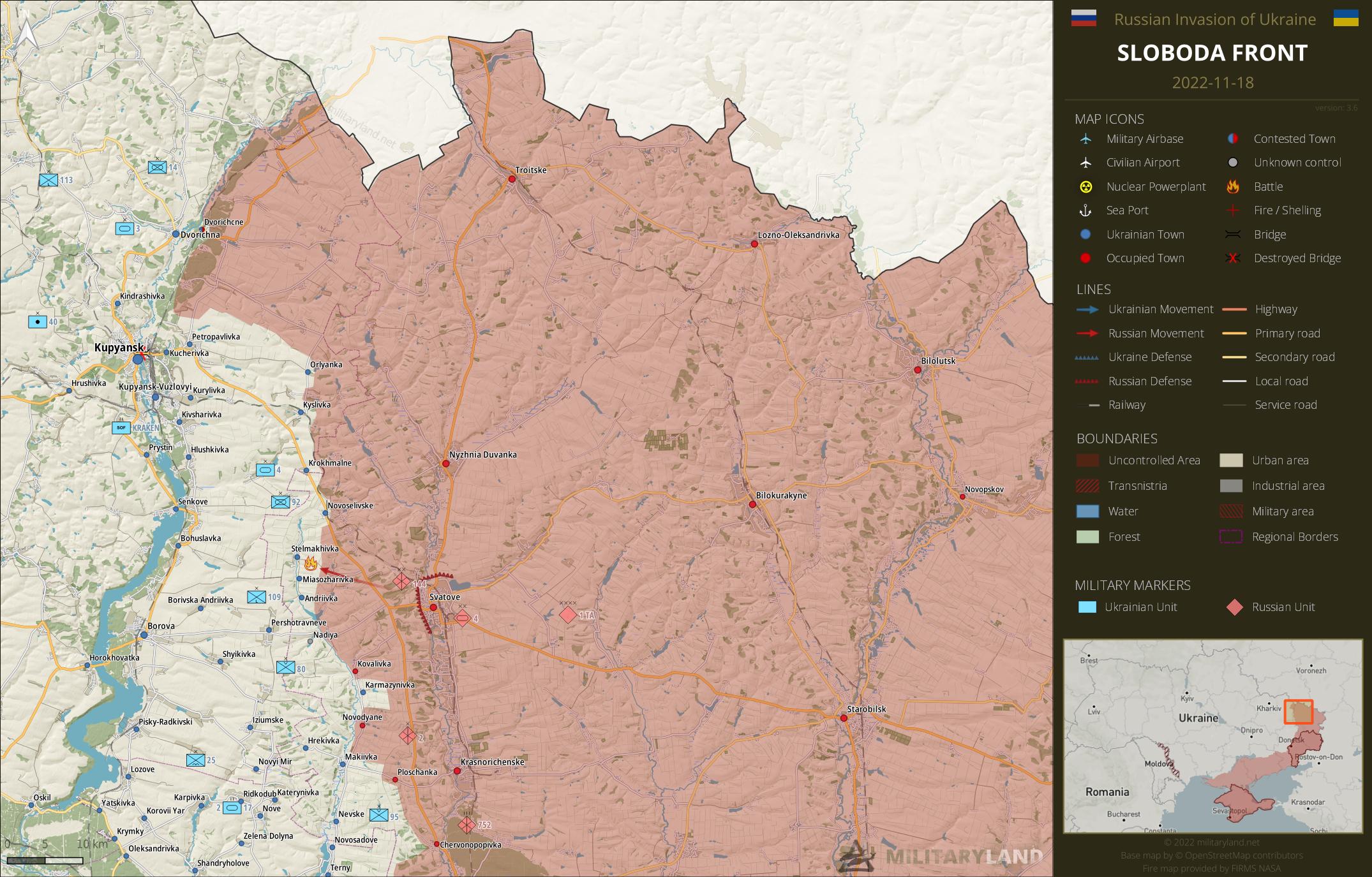
Svatove direction
- Ukrainian forces repelled a Russian attack towards Stelmakhivka.
- Novoselivske settlement is likely back under Ukrainian control.
Bakhmut Front
includes the vicinity of Bakhmut
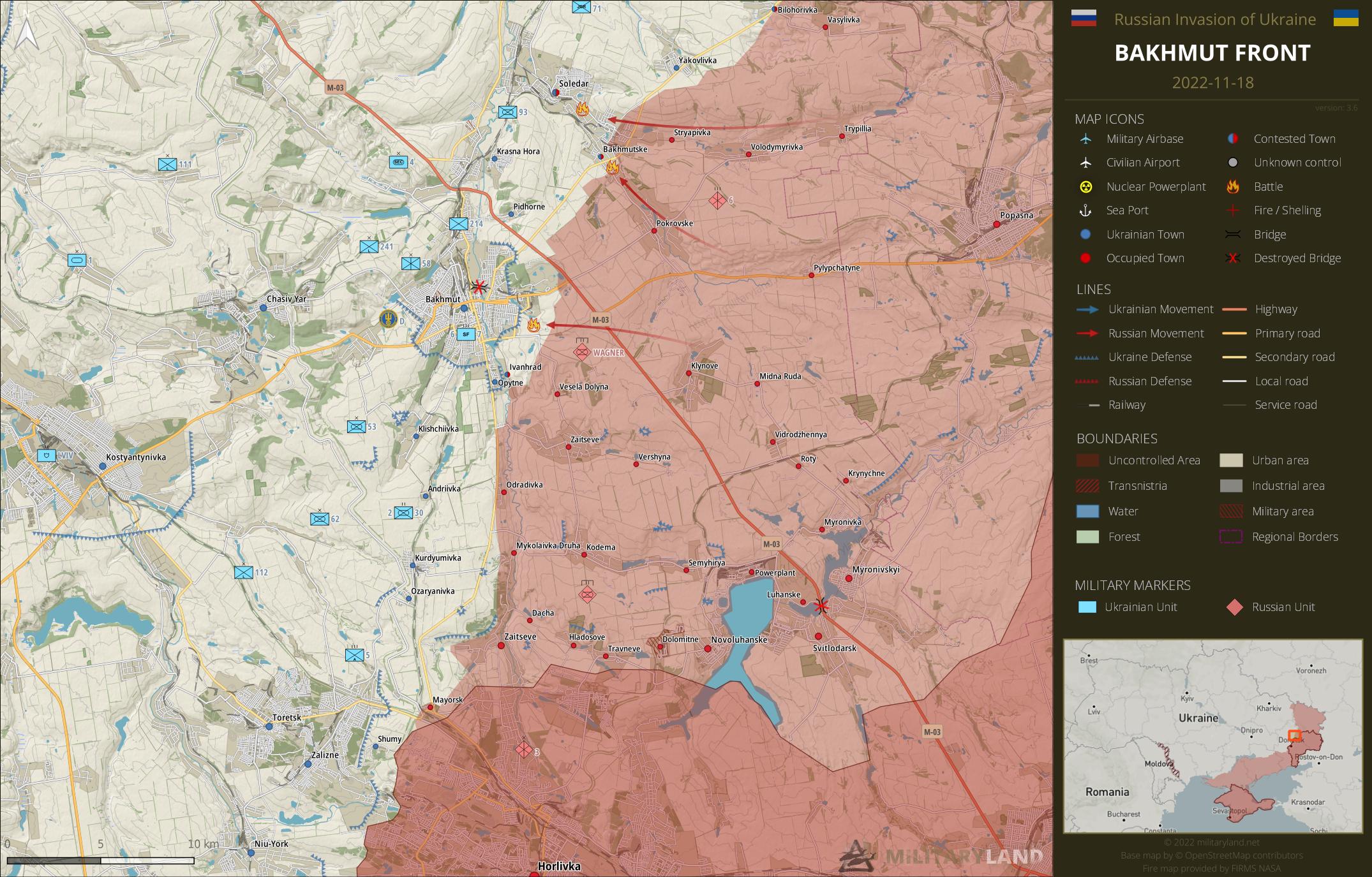
- Fighting continues in Soledar, Bakhmutske and in the area of Bakhmut. The situation, primarily near Bakhmut, is not looking good, at least according to Ukrainian soldiers on the ground.
Siverskyi Donets
overview map of Slovyansk, Kramatorsk, Bakhmut and Lysychansk vicinity

Lysychansk direction
- The enemy attempted to advance and seize new positions near Bilohorivka, Verkhnokamyanske and Spirne. All attacks were successfully repelled.
Avdiivka Front
includes the vicinity of Avdiivka

- All indicates that the enemy managed to gain full control over Opytne settlement.
- Russian troops attacked Ukrainian positions in the area of Vodyane, but without success.
- Russian forces are pressing hard on Ukrainian defenders in Pervomaiske. The village has been almost leveled by the Russian artillery fire, forcing Ukrainian forces to abandon some positions in the south-eastern part.
- The enemy managed to advance closer to Nevelske and captured Ukrainian positions in the vicinity.
Donetsk Front
includes the center and southern part of Donetsk Oblast
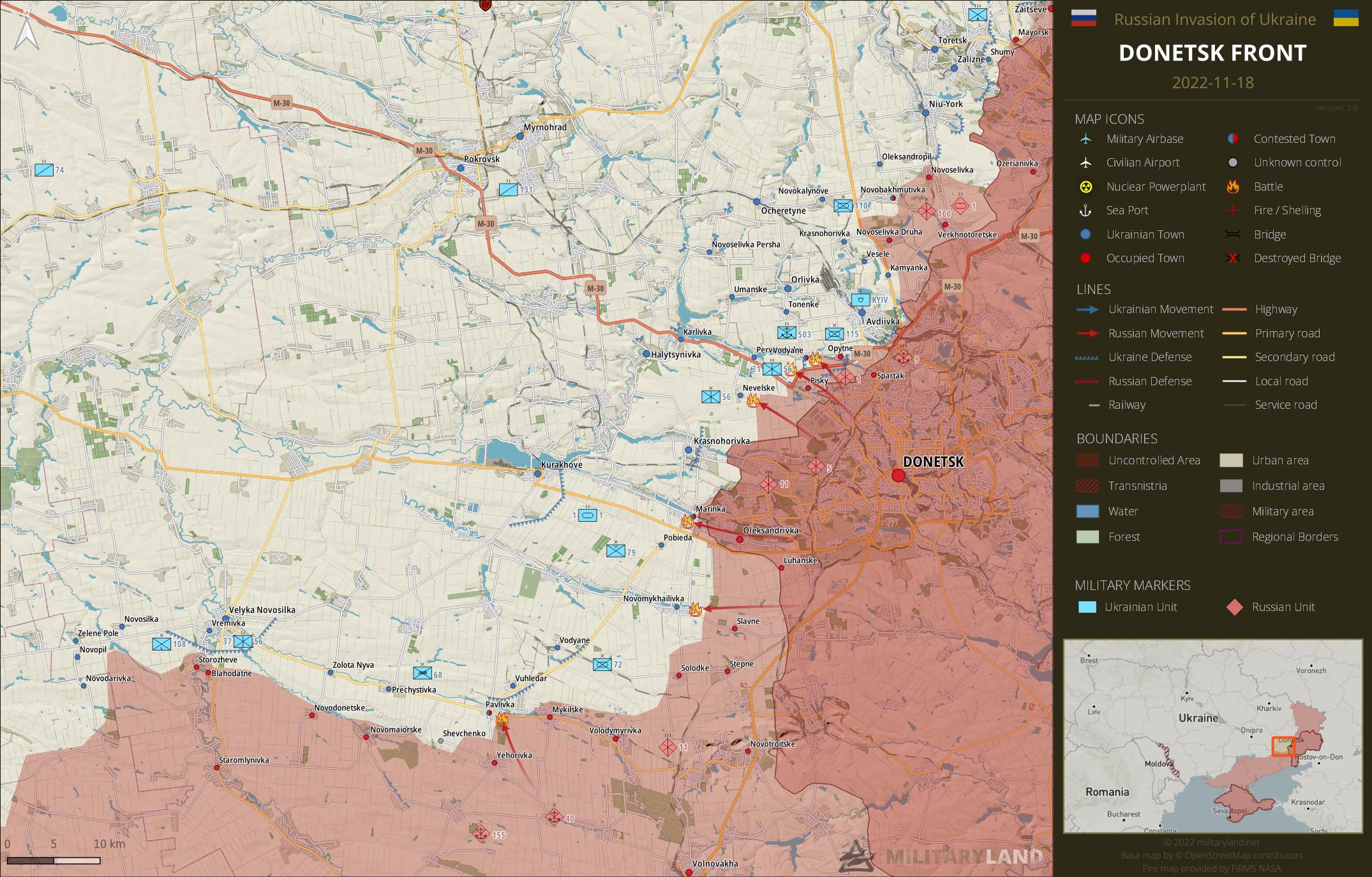
- Fighting remains active in Marinka, but there is no significant change for either side.
- Ukrainian defenders repelled a Russian attack towards Novomykhailivka and in the area of Pavlivka.
Zaporizhzhia Front
includes the Zaporizhzhia Oblast
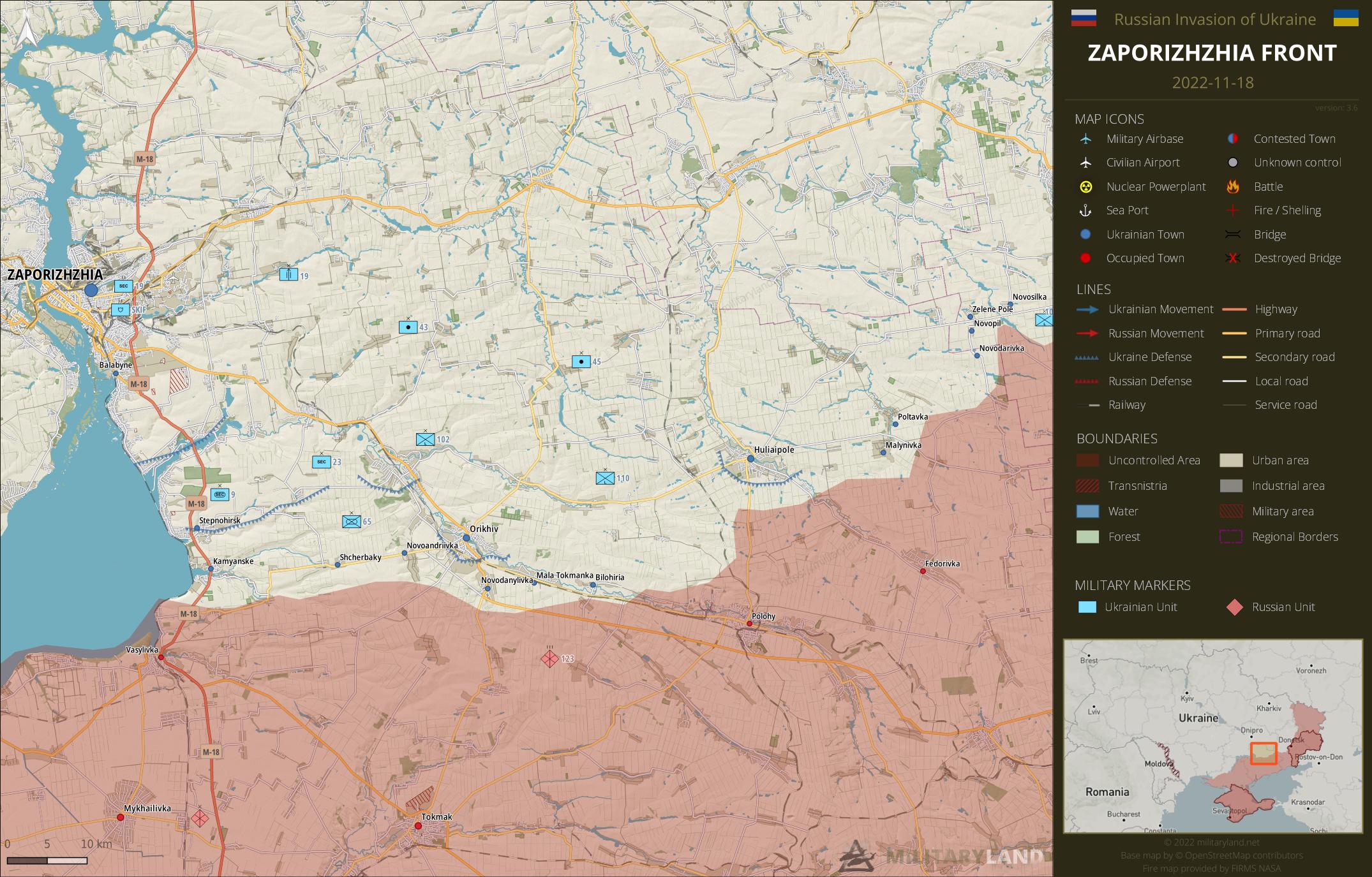
Zaporizhzhia Oblast
- No change on the ground during the past 48 hours.
Kalanchak Front
includes the left bank of Dnipro river south of Kherson and Kakhovka
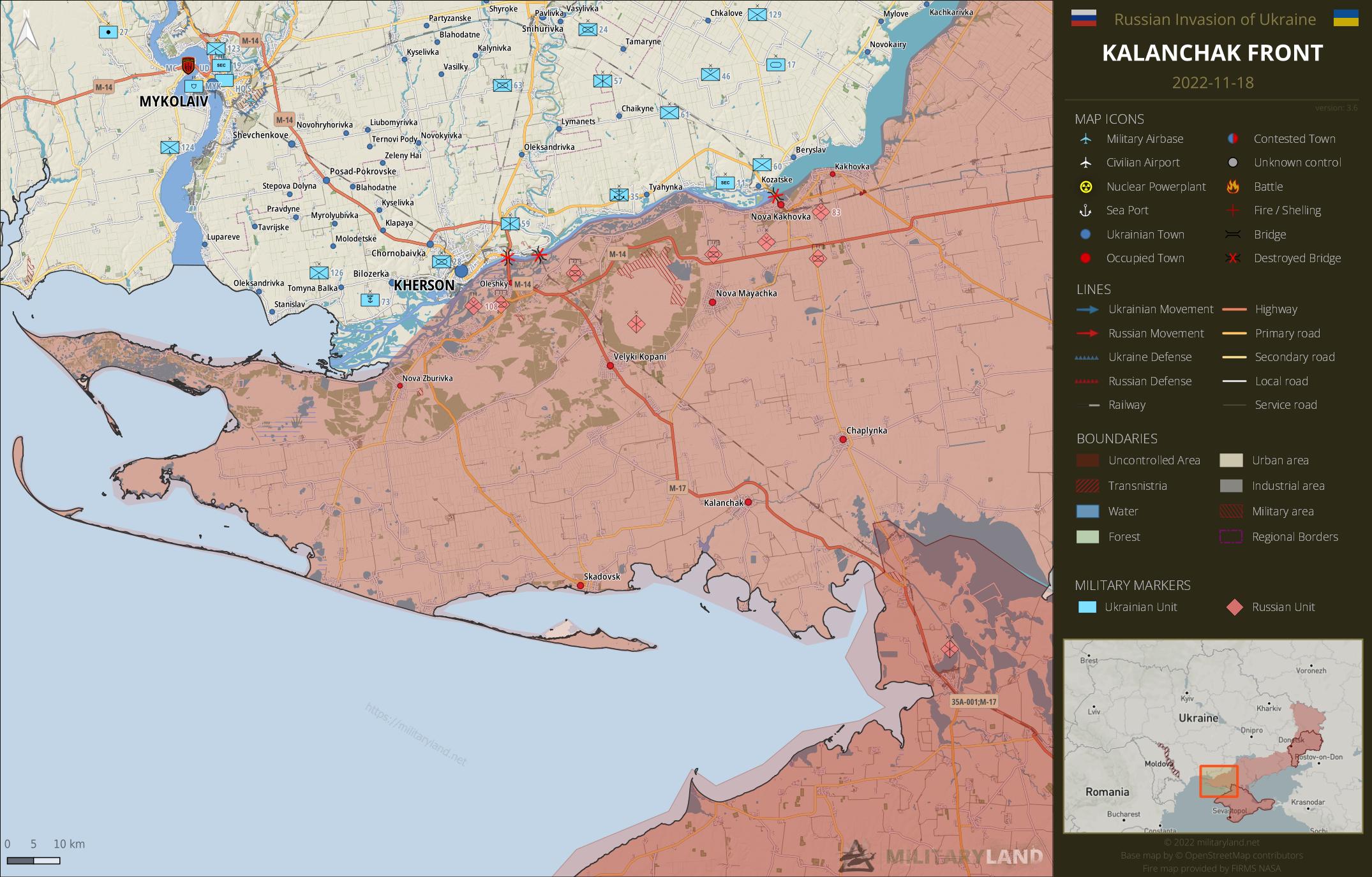
- No change on the ground during the past 48 hours.
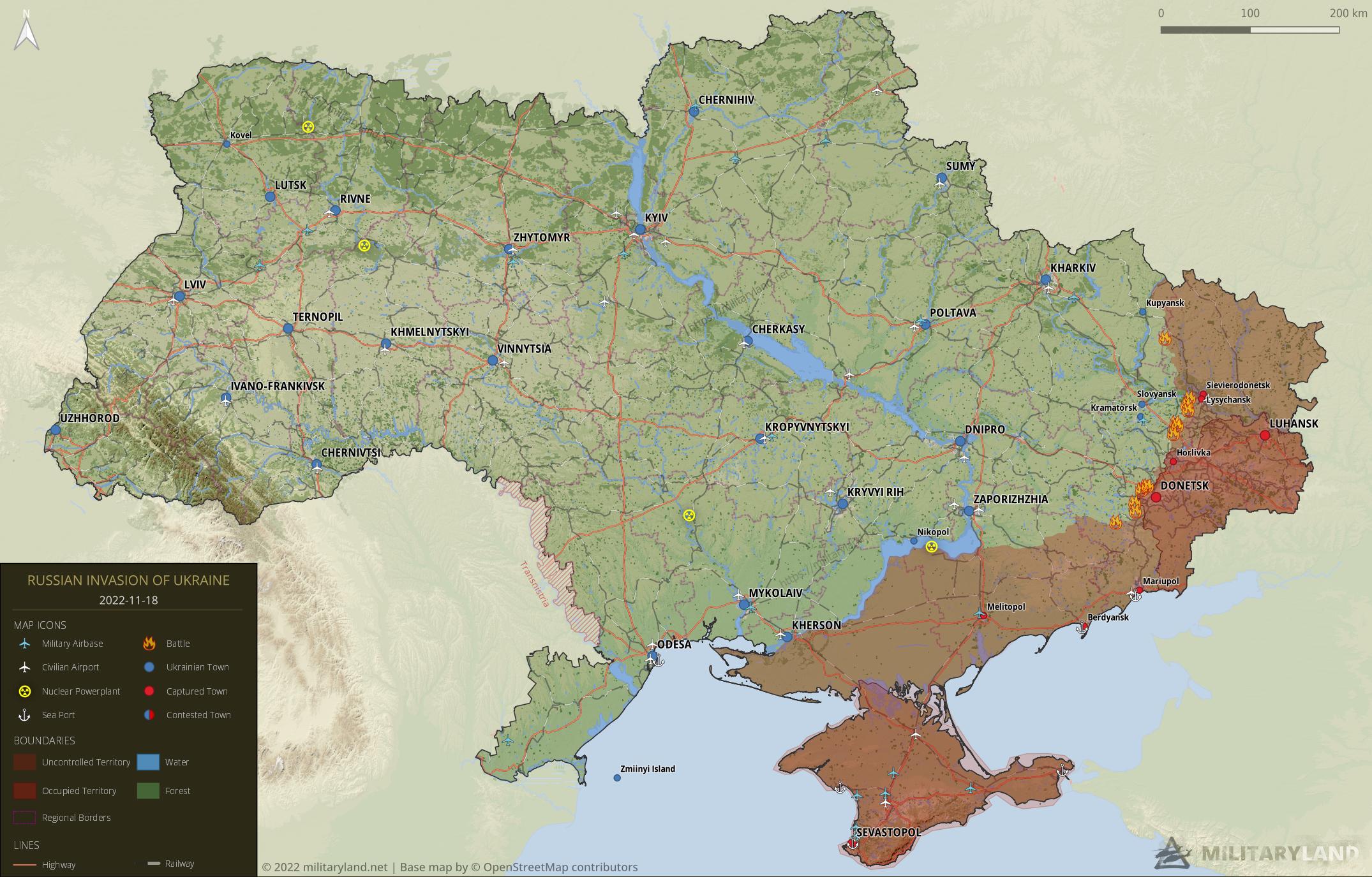
Full map
The full overview map of current situation.
Looking for an interactive map? We got you covered. Visit our original Deployment map.
If you would like to use our maps in your project, video or any other media, please visit Invasion maps page for more information.
This summary and detailed maps are based on the following sources:
General Staff of the Armed Forces of Ukraine, official media channels of Ukrainian regional administrations, Ukrainian Ministry of Internal Affairs, Security Service of Ukraine (SBU), geolocated footage and press releases of Russian Armed Forces, self-proclaimed DPR and LPR.
If you enjoy this content, the best way to support our site is by sharing it and following us on X, Bluesky and Facebook.
Topics:
Related posts
Our community
Mentioned Units
No unit mentioned.Support us
Have heard suggested, don’t know if realistic, Ukr. to advance cross the planes towards: Mariupol, Berdyansk, Melitopol. No big waters on that route, planes ain’t best place for fortifications, i.e. less effective there. Theoretically, if successful RU controlled is divided in 2, plus Russian’s in South taken in the rear. Wonder if RU can keep South forces supplied, Kerch Bridge damage considered.
Just to clarify for others. He is talking about “plains” on the ground, not planes in the sky.
Thanks for your great work as always, Jerome! I’m not an expert in war strategies and tactics, but I’m curious about the “peacefulness” on the Zaporizhzhia Front. Do you think/is there any rumours about a push by the Ukraine Forces soon in the region? And I find odd that Ukraine didn’t recover the control of the East of Dvorichna yet… Didn’t remember of any battles there since the Kaharkiv front
The Zaporizhzhia Front is in the mud season. May be if and when the ground freezes. I heard that it may not freeze at all in the south. Concerning Dvorichna i would guess that it is not high on the agenda and that the tactical situation ain’t inviting.
Thanks for the great work as always, Jerome! I’m not an expert in war tactics, but I’m really curious about the “peacefulness” on the Zaporizhzhia Front. Do you think that Ukraine can start pushing in this front soon/is there any rumours about an advance?
if last time was 14th for 264 dans of war, un 19th should be 269 !!
but, all in all, thanks for you great job
First paragraph: “as of 18th November 2022 – 22:00 (Kyiv time)”. That’s 268.