Invasion Day 154 – Summary
The summary of the 154th day of Russian invasion to Ukraine, as of 22:00 – 27th July 2022 (Kyiv time).
Day summary:
Russian forces captured Novoluhanske and Vuhlehirska power plant as Ukrainian troops retreated to avoid possible encirclement. The enemy is slowly approaching Bakhmut from the south and east.
North of Slovyansk, Ukrainian forces counter-attacked and likely pushed Russian troops back to Pasika, maybe even furthermore. Russian army possibly allocated most of its forces in the area to capture Bohorodychne and weakened its flanks. The countless failed attacks on Bohorodychne subsequently weakened the strength of the whole Russian force, and Ukrainian troops have used it to its advantage.
Kharkiv Front
includes the area of Kharkiv and Chuhuiv
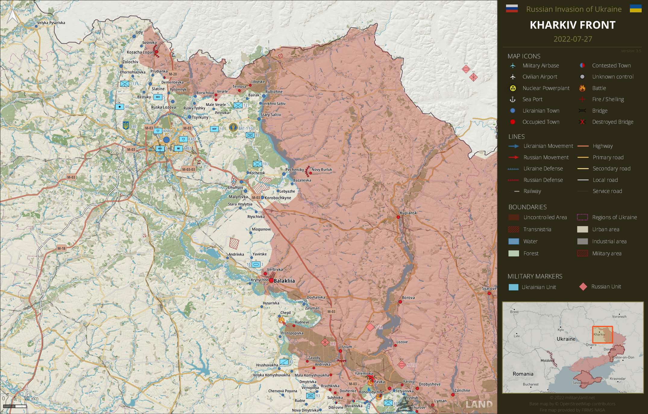
Kharkiv & Chuhuiv direction
- Ukrainian forces revealed and eliminated a Russian reconnaissance group near the Chepil settlement.
- Russian army has reportedly started to improve logistical support in the area, primary by building additional pontoon bridges.
Correction: Rudneve was incorrectly marked as Ukraine controlled settlement. Based on released footage, it’s been occupied by Russian forces for at least a month. Thanks for the heads-up!
Bakhmut Front
includes the vicinity of Bakhmut
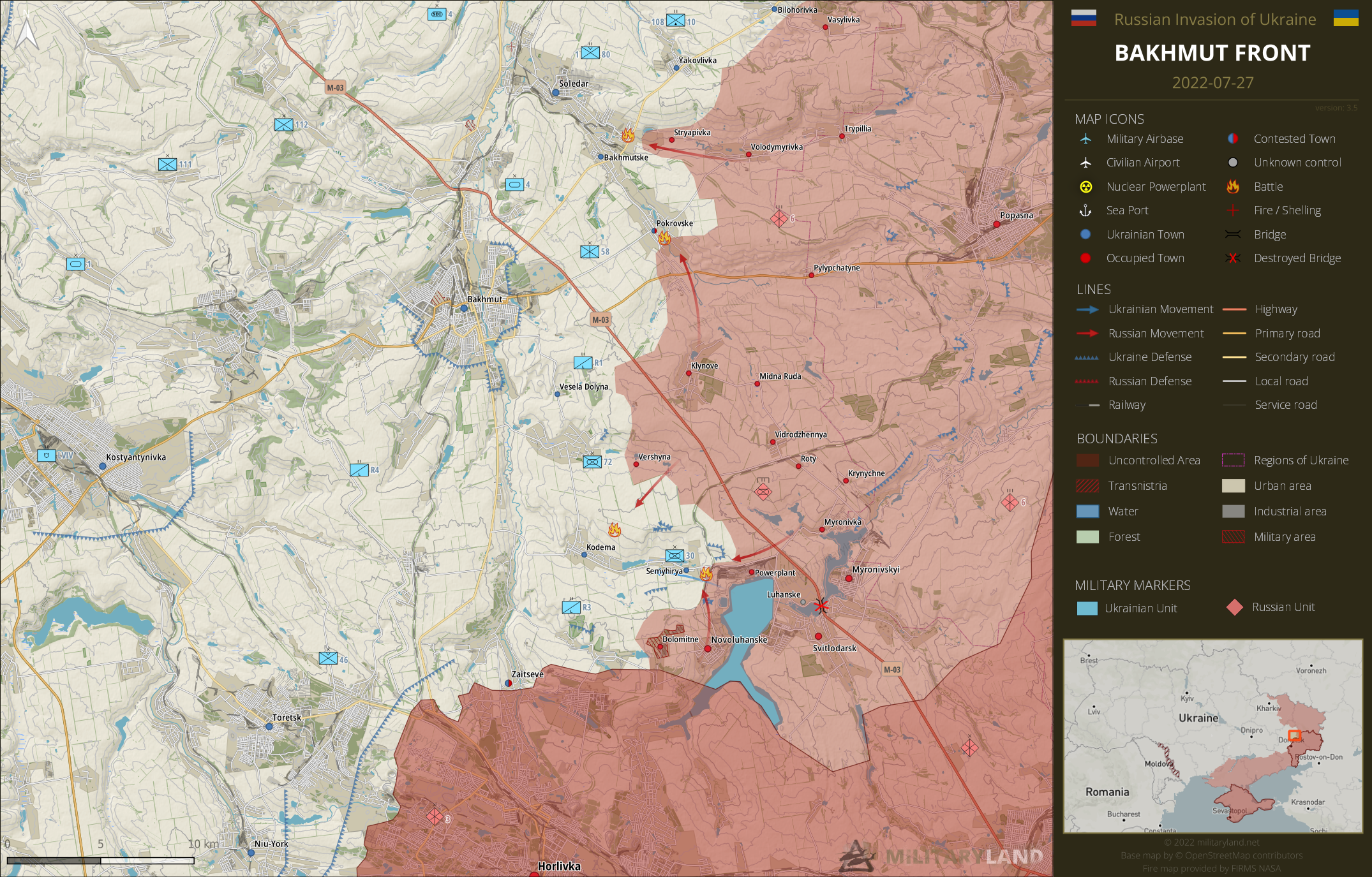
- Russian forces advanced closer to Soledar from the direction of Volodymyrivka.
- Fighting continues on the outskirts of Pokrovske. Russian army has reportedly ground and air superiority.
- Ukrainian troops withdrew from Vuhlehirska power plant and Novoluhanske towards Semyhirya to avoid encirclement.
- The enemy has attacked Ukrainian positions in the vicinity of Semyhirya and Kodema. Heavy fighting is ongoing.
Slovyansk Front
includes the vicinity of Slovyansk and Kramatorsk

Slovyansk direction
- Russian reconnaissance group attacked Ukrainian troops near Pasika. The enemy group was neutralized.
- The information above, as released by Ukrainian General Staff, is indicating that Ukrainian forces successfully counter-attacked in the area of Dolyna and reached the vicinity of Pasika. Satellite imagery released today (June 27) shows destroyed/removed a Russian pontoon bridge near Yaremivka.
- Another attack in the vicinity of Bohorodychne was repelled by Ukrainian troops.
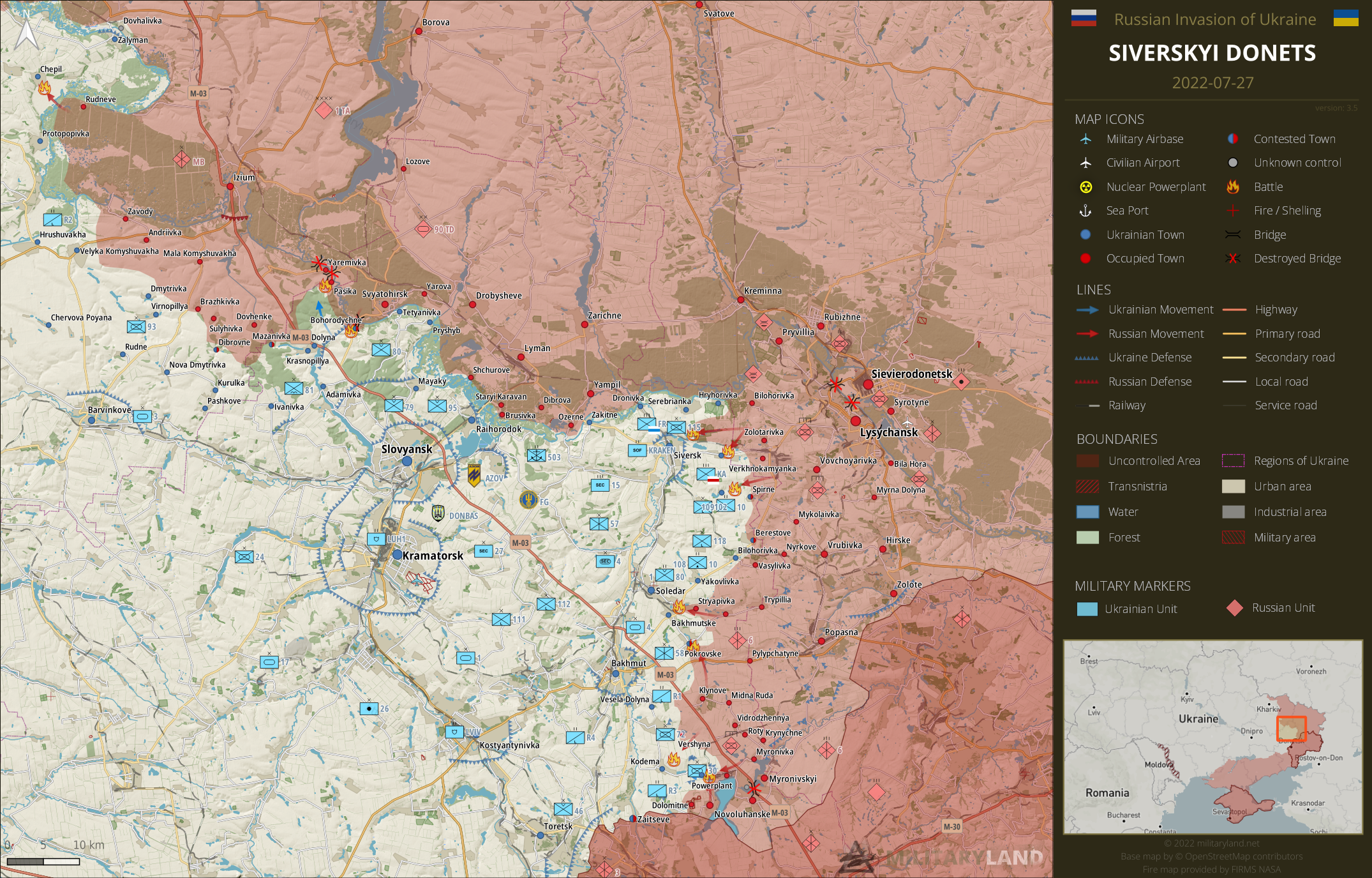
- Russian forces advanced closer to Siversk, threatening to cut Ukrainian troops at Serebrianka and Hryhorivka.
- Russian troops continue to attack Ukrainian troops in the area of Verkhnokamyanske. The defense lines are holding.
- The enemy tried to advance closer to Ivano-Darivka, but without success and retreated.
- Russian troops partly withdrew from Berestove at night. The village, or rather what remains of it, is now contested.
Siverskyi Donets
overview map of Slovyansk, Kramatorsk, Bakhmut and Lysychansk vicinity
Donetsk Front
includes the center and southern part of Donetsk Oblast
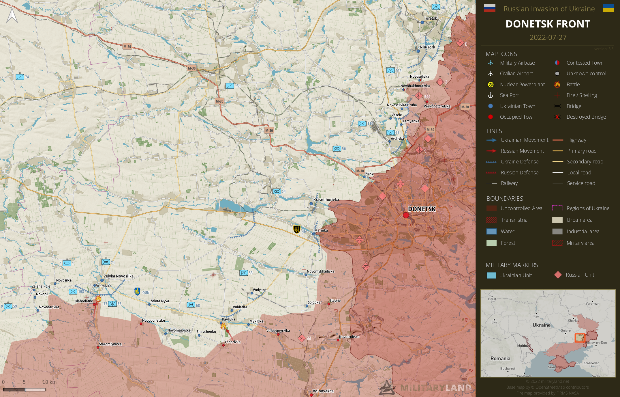
Donetsk Oblast
- Russian forces attacked Ukrainian positions at Pavlivka. The attack was repelled by Ukrainian defenders.
- The enemy tried to advance in the vicinity of Blahodatne towards Velyka Novosilka, but Ukrainian defenders repelled the assault.
- Heavy shelling was reported from Avdiivka on July 27, but Russian troops didn’t launch a ground attack.
Zaporizhzhia Front
includes the Zaporizhzhia Oblast
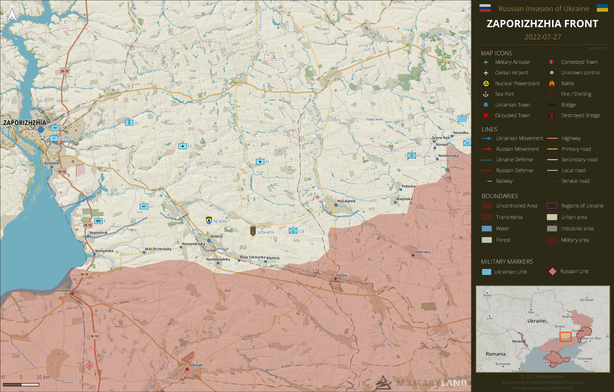
Zaporizhzhia Oblast
- There was no change on Zaporizhzhia front.
Kherson Front
includes the vicinity of Kherson and Mykolaiv
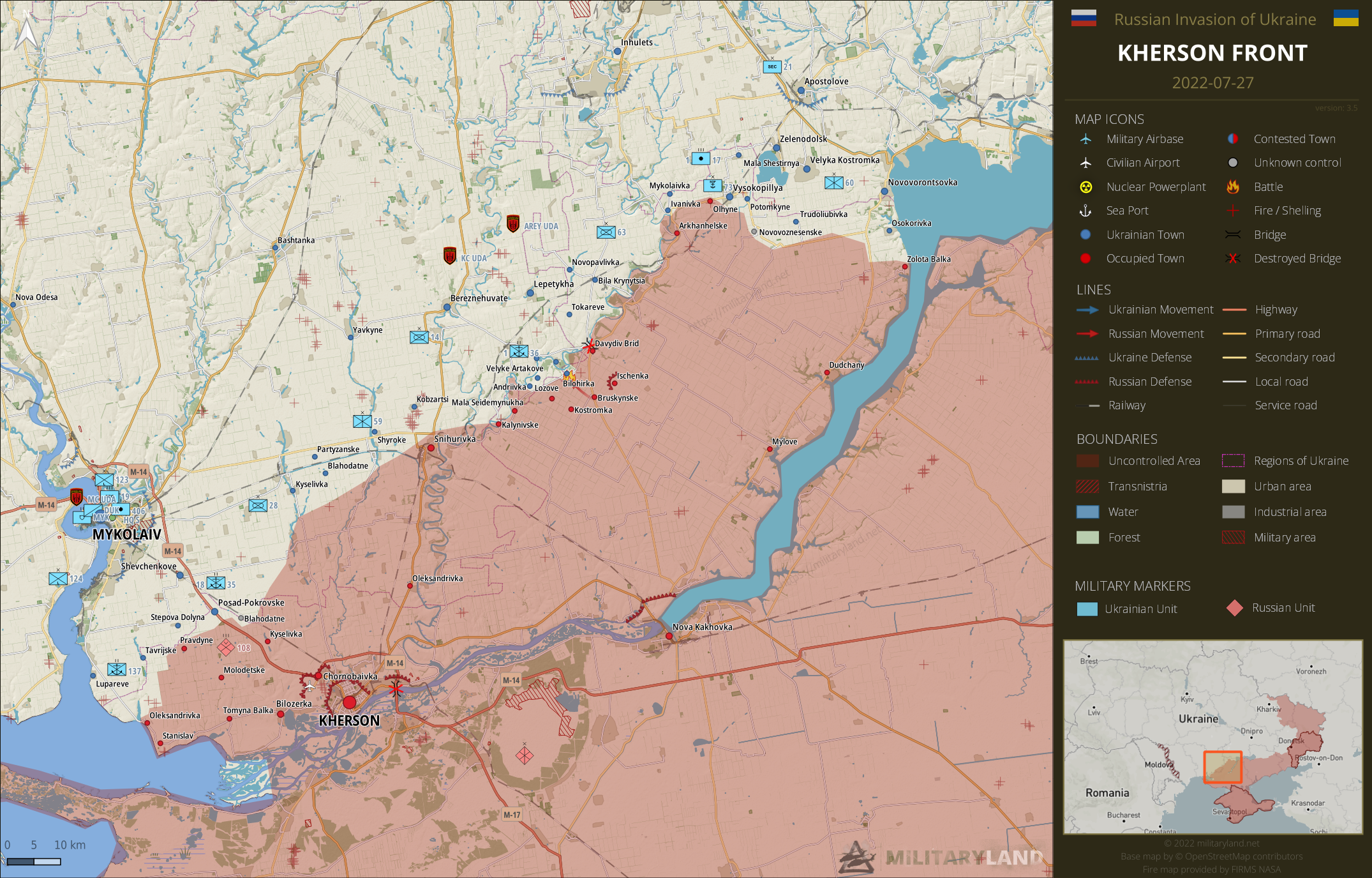
- Ukrainian troops repelled a Russian attack towards Bilohirka.
- Ukrainian artillery (likely HIMARS) targeted a road bridge near Kherson. The bridge is heavily damaged and unusable at this moment. Ukrainians also targeted a nearby railway bridge, but no further details are known at this moment.
Ukrainian side announced a strict embargo on all information regarding Kherson Oblast and advance of Ukrainian troops. The only allowed source for this area are the reports by Ukrainian General Staff.
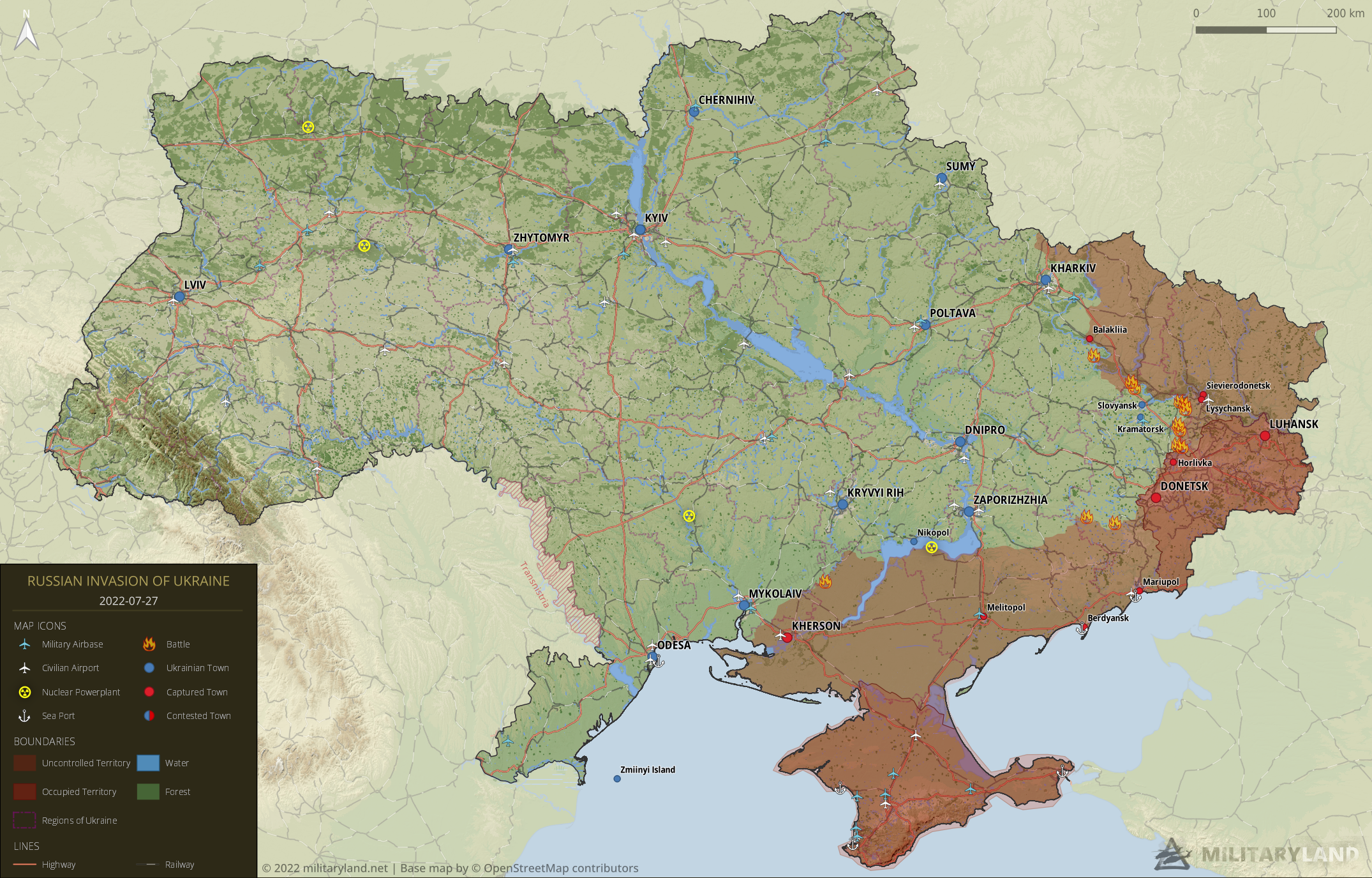
Full map
The full overview map of current situation.
Looking for an interactive map? We got you covered. Visit our original Deployment map.
If you would like to use our maps in your project, video or any other media, please visit Invasion maps page for more information.
This summary and detailed maps are based on the following sources:
General Staff of the Armed Forces of Ukraine, official media channels of Ukrainian regional administrations, Ukrainian Ministry of Internal Affairs, Security Service of Ukraine (SBU), geolocated footage and press releases of Russian Armed Forces, self-proclaimed DPR and LPR
If you enjoy this content, the best way to support our site is by sharing it and following us on X, Bluesky and Facebook.
Topics:
Related posts
Our community
Mentioned Units
No unit mentioned.Support us
Do we have clear evidence that Visokopillya is under UKR control?
What makes you doubt?
No clear evidence for me too. Just one or 2 mention in ua report.
It will not be the first time we dont understand their short report.
And with the Black out …
Many ukrainian sources say that it is under russian control and that russians are blocked from three sides. And General Stuff of AFU do not disprove this information. I think this at least deserves further investigation.
Here’s explanation why I have it as Ukraine controlled.
https://twitter.com/Militarylandnet/status/1550781266231967745
“Russian troops partly withdrew from Berestove at night. The village, or rather what remains of it, is now contested.”
Where did you get that information from?
“Russian forces advanced closer to Siversk, threatening to cut Ukrainian troops at Serebrianka and Hryhorivka.”
Where did you get that information from?
The armed forces of Ukraine stated just now that the RU improved their positions in the directions to Soledad and Vershina. So, there you have the tactical RU advancements towards Bakmut from the northern and southern flanks, to cause another 3/4 encirclement and force the Ukrainians to retreat.
I just saw here these photos of RU troops at the Vuhlehirska Power Plant dressed in Ukrainian uniforms!! What’s up with that?
usual Russian war crime, not the 1st time, not the last. They did that trick numerous times. Including now in Avdeevka (Donetsk area)
The bridges of Kherson Oblast are going to play a huge role in the next phase. Being able to destroy or make them impassable, Ukraine can carve up the Russian positions in the south and hit them in isolation. This is in Kherson as well as the rest of the south as R troops in Kherson can’t redeploy.
That’s how I see it too. But what will be the next step? Use the Dnieper as a natural barrier for defence by reduced forces and lead the freed forces to Zaporizhia and Donetsk? To break the land connection between Donbass and Crimea there?
We don’t know how big the Ukrainian army is going to be in the next couple of months so it’s hard to predict what their next moves will be. They’ve kept the scale of their mobilization under wraps so we, as well as the Russians, have to keep guessing for a while.
I’m not even saying they’ll necessarily push hard against the forces that are across the river in Kherson as the first order of attack. They may just pin them down there and hit towards Melitopol first, or somewhere else. Russia is stretched thin at this point and Ukraine is still building up.
Hi,
thanks to all that work here! I am interested on the actual situation of Oleksandrivka and Stanislav west of Cherson. Here both are assessed as of under Russian control. Here both are assessed as of under Russian control. Other sources, however, claim Oleksandrivka under Ukrainian control.
As of July 19, under Russian control.
https://twitter.com/Militarylandnet/status/1550768208264761349
The RA nevertheless climbed on Avdeevka in the forehead. Yeah, strategists, damn it. Well, let’s see when and with what losses they will take it. A lot of soldiers will put, IMHO.
Liveuamap shows quite significant UA advances in Kherson oblast
https://liveuamap.com/en/2022/28-july-the-armed-forces-of-ukraine-destroyed-russian-ammunition
I don’t see anything new…
They took more territory around the Andriivka-Bilohirka-Dadyviv Brid axis and are moving further south.
that part of the map was not updated since the last bridgehead attempt
Liveupmap update this part of the map yesterday i think.
Nothing significant, just small gain. Lozove and andriivka.
Kherson official says Ukraine will take Kherson oblast back before September: https://www.ukrinform.net/rubric-ato/3536020-ukrainian-forces-to-liberate-kherson-region-from-russian-invaders-by-september-deputy.html
If Kherson official says, it is true, because he knows the future very well.
Shelling bridges and static positions with artillery is one thing, crossing rivers with troops and armoured vehicles is another thing. Russians experienced this when they tried to cross the siversk river.
One of them also said that in April, so I’m not holding my breath…
The Ukrainians wouldn’t have to cross any rivers to take Kherson. On the other hand, the Russians have to cross a very, very large river to resupply their troops in Kherson.
Kherson oblast (as Ardiana stated above) extends quite far east of the Dnipro River. The city of Kherson, though, is in very dire straits.
Kherson city would have been the perfect spot to stop Russians. All they needed to do is fortify those few bridges. If only they didn’t have traitors in the city council that just let Russians walk in. But they can still regain the city, replace the leadership and regain that…
this whole resupply problem might not be as huge of an issue as expected, there are many ways to resupply and with the suppies that are already there, i am expecting them to last for months if not for ever. they have started to use ferrys which helps and for heavy equipment they might use helis
“Many ways to resupply”? Care to enlighten us how would you resupply a city of 283,000 with army of couple of tens of thousand soldiers?
that’s what Goering said to Hitler about Stalingrad… truth is, amount of troops on west bank of Dnipro is quite large and requires a lot of supplies.. ferrys wont be able to keep up with the amount required daily.. especially when its in range of Ukrainian artillery..
Ah, Stalingrad. The difference is the Ukrainians don’t have air supremacy and never will. Aircraft are decades more advanced and UA hasn’t been able to launch a successful offensive at any point in the war.
nah, that metaphore is deeply misplaced. Throwing more troops to defend the Kherson is stupidity (politically understable), the more troops/hardware – the harder the supply situation become.Neither side has an air supremacy and won’t have.
Stalingrad? Seriously ?
Stalingrad start with 160 k vs 270k. And finish with 1100k vs 450k.
Kherson is what ? 3k vs 10k?
I hope they keep using the ferry to move tanks. All it takes is one shot from 155mm on the ferry to sink the whole kaboodle.
Typical propaganda. Same story from couple weeks already. I have feeling that they are not keen to take over this land anymore. Kherson was lost in couple days without flight. Maybe people there want to be in Ru?
The resistance of the local population is still very high, and expresses itself on many levels. Despite all the brutal pressure that the Russian occupiers put on the people there. Not my personal opinion, but the accounts of local residents, which I am reproducing.
Between 2014-2018, I travelled to Kherson perhaps 10 times. I know the oblast well. This is the most pro-Ukrainian part of Ukraine’s south. Now this is starting to change – but slowly.
The pro-Ukrainian attitude in Kherson is crumbling? What findings lead you to this assessment?
Please read carefully, I did not say crumbling. I read interviews of pro-UKR Kherson residents. They say 70% are pro-UKR, while 30% are either pro-RUS or willing to adapt to the new realities. If nothing changes, the number of those ready to go with the flow will grow. It’s called human nature.
You suggested a slow reduction of pro-Ukrainian attitude. I got another impression according to my family ties to that region. Much more an analogy to Haldane’s Rule from biology on a psychological level. Sharpened demarcation, thus, the opposite. The RU part of the heart of so many went silent.
The land is Ukranian.
Regarding Russia’s increasing reliance on “volunteers”, I still can’t make up my mind as to whether this is evidence of really serious shortage of manpower or a calculated move to spare the professional units in Russia in case a new front opens up elsewhere.
both. Putin avoids at all cost a regular mobilisation and sending ‘good boys from Moskva’. RU prefers using proxies, its colonial subjects and mercenaries even if it costs a lot. Elite units were and are used (VDV, Specnaz, Marines) even in idiotic deployments (as a mechanised infantry).
the problem with elite troops like speznas are that they are quite literally trained to do fast engaging tactics for example a hostage rescue, but in war they just become really good units/better trained units.also mechanised infantry is considered to be the elite force in both sides.
Mechanized Brigades are not the elite of Ukrainian Army, AirAssault units are.
oh yeah. forgot about them, but that mechanized brigades are top tier forces still holds.
mech infantry (unlike specialised units) are just ‘grunts’ nowadays. Using elite forces (airborne etc.) as such is like tying the racehorse to the plow. This is a sign how abysmall the state of RU regular forces is. Besides these they just throw ‘mobiks’ (especially proxies) in mass with arty.
Evidence has emerged that Novoselivka Druha is not under the control of the UA. Geolocation of the destruction of positions of the Russian on the road Avdeevka – Konstantinovka 48.199743, 37.778964 https://twitter.com/PaulJawin/status/1551814641491263488
Thanks
It seems clear Russia’s attention has shifted to attacking Soledar + Bakhmut and defending Kherson. Elsewhere it can’t do much because it is stretched thin. I don’t understand their tactics at all.
From what I understand, their tactics have been to advance from the northern and southern flanks, maintain some offensive on the east and attempt to cause a 3/4 encirclement to force the UA forces to retreat to the west. Maybe they are trying to advance towards Bakhmutske-N and Kodema-S?
And the (non) tactic on the UA has been a war of attrition or resisting as much as they can slowling the RU advancement and making the RU pay a great cost for every inch they gain.
Makes sense. Thanks
They have solid defense lines in Kherson, Ukraine hasn’t been able to breach them. And I’m sure they keep switching pressure points to whichever direction is more vulnerable. Their tactic all along has been to keep pushing until they get through somewhere. That’s why those pockets keep forming.
The UA tactic in Kherson is to cut off the RU from the supply lines and command posts (i.e., bombing bridges, ammo hubs, operational centers, etc.). Here the tables get turned. It will be interesting to see how long the RU is willing to hold out while they become increasingly debilitated.
Cutting the bridge worked to the extent that they had to build a makeshift ferry service. But in case the objective is to get them to flee voluntarily by leaving them a way out, it’s not working: https://liveuamap.com/en/2022/27-july-russian-forces-have-set-up-a-ferry-next-to-the-destroyed
Indeed, Russian administration in Kherson said they would build pontoon bridges and start ferry services. Not sure if it can make up for the inability to use existing bridges though.
I wouldn’t be so sure. It is reported that the Ruskis in Kerson were running around like someone kicked an ant hill after the bridge was blown out. They have taken heavy losses in officers and comms units and the train of equipment shipped through Melitopol will now need to be ferried to get across.
That ferry service can move perhaps a half dozen lightweight vehicles every half hour. That is a trickle compared to flow rate across the bridge. Even a pontoon bridge will only have a small fraction of the flow capacity; and pontoon bridges are much easier to incapacitate.
And I personally would not like to be on that ferry making always the same route and very slowly over and over again in an open space. That’s begging for trouble.
It’s good target practice for sure. Maybe shoot every 1/4 ferries at random intervals just to keep the Russians guessing and raise their anxiety level? “Will we die this time…?”
BTW, Kherson oblast is largely flat terrain. Is it not a big disadvantage for the attacking party (in this case the UKR side about to counter-attack)?
there is a lot of obstacles on the way (like channels). Besides on such terrain you are exposed for the fire/artillery/aviation. Besides there is a big city. I’d bet that the UK will politely nudge the RU for yet another ‘goodwill gesture’.
If someone stabbed you with a knife would you keep “giving them warnings” multiple times you’re about to hit them? Of course not. Just punch their lights out.
IMO Ukr cannot afford bloody and costly assault on entrenched positions and city (which also would ruin the city itself). So the ‘goodwill gesture’ is an optimal scenario (see Snake Island). I bet that the Ukr. want their land back in the best possible state not another Mariupol.
Yes the larger visual range is a big disadvantage for anyone trying to advance in cover, easier for defenders to spot early and react to. Takes alot of coordination through planning and combined arms or overwhelming force with mass casualties. More precision and counter weapons involved than in WW2
Kharkiv front bridges: i saw pictures of the destroyed bridge in stari saltiv, long time ago. Also there were reports that the bridge north of rubzhine was destroyed in june by ukraine.
By the way, you wrote me “..half of your country was occupied from russia, got mother’s home bombed to ashes twice..” What the country is it????? I have no idea. REALLY.
Germany. Make that one third of the country instead of half…. my mother lost 2 homes in ww2 as a child in dortmund and hanau. My grandpa lost half his butt and the other half his lever. I think i can freeze a little for stopping the next big idiot since hitler.
Understood. For reference: “your” houses were bombed by the Anglo-Americans you so loved, the USSR had nothing to do with it. But of course Russia is to blame. Egal… If you want – freeze for ideological reason, I – don’t want.
Ideology? No, i will freeze for the levers butts and houses of ukrainuans russians and the rest of europe. Putin must be stopped, just like hitler.
leave him be, he should be banned already (and isn’t unfortunatelly). Just yet another Putin’s cheerleader.
Instead “freezing” just buy another jumper and let’s that hysteric “we will freeze” nonsense be put into rubbish where belongs.
No – ruzzian troops just raped their way to Berlin. Nothing new then.
Kharkiv front, rubhizne: i personally would put rubizhne on contested. There were fighting reports on it i think in june and even though it is front line, it very seldom shows in shelling reports. I think ukraine just holds small parts of the area.
E.g.: both stativs south of it are being shelled reguarly.
What about Pokrovskoe? Russia claimed its conquest. Plus I don’t think pushing russians back in Pasivka is a victory. Judging by your map, it would be an encirclement
I’ve not yet seen a solid proof about Pokrovske.
A lot of “fake” victory messages from the russian side but nothing de-facto. Maybe 1-2 days later.
Rybar (and some others) claimed Pasivka taken. It would not be the 1st time when presence of recon elements were interpreted as ‘control’. Bear in mind that Siversk was already ‘taken’ like… 3 times?
I am not sure what to make of the Pasika information. There is corroborating evidence to suggest UA are operating there (and have been for several days), however whether this is symptomatic of the condition of the Russian line South of Izyum or simply a successful UA local action remains to be seen
Yes, it’ll be very interesting to see how this turns out. My guess is that UA troops are not in control of Pasika, but have positions somewhere in the foresty area.
Foresty area who was use by russian to attack bohorodochine.
Have russian ponton is this village under ukrain artillery ?
Wait and see.
If ukraine takes back those forest hights, russia will be back to the lines of may or even april.
I agree, as the movement of RU units to shore up occupied Zaporizhzhia/Kherson Oblasts may be creating unintended gaps that UA are moving into. It will be a matter of waiting to see how it develops as at this juncture we have insufficient data points to draw a conclusion.
That’s a very odd place for a gap… the 1st Tank Army HQ is 20 km away… It will be interesting if Ukraine can control those villages and the river crossing, and to also put pressure on the Tank Army. It would be a nice bonus, even if they can’t push back further.
Denys Davydov just said Ukraine pushed back not only from Pasika but the whole southern front line: https://www.youtube.com/watch?v=fXFPyHbtKp4
I like the guy but he is overly optimistic and often draws pretty wild conclusion from a little evidence. I’d say that was an opportunistic move – RU left or was disorganised, UKR went into an advantageous position (heights in forest maybe). There is a lot of moves and a little clarity.
I see Dibrovne – Mazanivka are also marked as Contested in this map… I don’t know whether his information is up to date or if he got some NEW information on top of that.
no idea either
since the war is contantly changing you can’t quite always put every new information in or know if it’s correct. he uploads his maps every 2 days and can’t change them if already uploaded and so puts the newest information into the next summary. it’s not a interactive map, but they do have one.